USGS To Conduct Aerial Fault Mapping In Oklahoma | Aero-News Network
Aero-News Network
RSS icon RSS feed
podcast icon MP3 podcast
Subscribe Aero-News e-mail Newsletter Subscribe

Airborne Unlimited -- Most Recent Daily Episodes

Episode Date

Airborne-Monday

Airborne-Tuesday

Airborne-Wednesday Airborne-Thursday

Airborne-Friday

Airborne On YouTube

Airborne-Unlimited-07.07.25

Airborne-NextGen-07.08.25

AirborneUnlimited-07.09.25

Airborne-FlightTraining-07.10.25

AirborneUnlimited-07.11.25

Fri, Aug 18, 2017

USGS To Conduct Aerial Fault Mapping In Oklahoma

Surveys Will Take Six To 10 Weeks To Complete

Scientists with the U.S. Geological Survey and Oklahoma Geological Survey are teaming up to better understand the location of deep faults and subsurface geology via airborne technology.

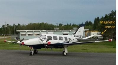
USGS and OGS are contracting Goldak Airborne Surveys to conduct surveys that will fly over 18 counties in the southwestern and north-central part of the state. The goal is to capture 3-D images of geology beneath the Earth’s surface for earthquake hazard and mineral resources.

Weather permitting, the surveys will take approximately 6-10 weeks to complete. Operations will be based out of Altus, Oklahoma.

“Oklahoma has been experiencing increased seismicity since about 2009. Many of these earthquakes occur on faults that haven’t been mapped,” said USGS scientist and project lead Dr. Anji Shah. “In order to better understand local seismic hazards, the USGS and OGS will use the new data to work towards improved fault maps.”

Instruments on the airplane will measure variations in the Earth’s magnetic field created by different rock types up to several miles beneath the surface. The magnetic field maps will help with imaging faults as well as intrusions, which are rocks formed by ancient volcanic eruptions that never reached the surface. The scientific instruments on the airplane are completely passive, with no emissions that pose a risk to humans, animals, or plant life.

Survey areas will include parts of Alfalfa, Beckham, Comanche, Greer, Harmon, Kiowa, Jackson, Lincoln, Logan, Major, Noble, Pawnee, Payne, Pottawatomie, Stephens, Tillman, Woods and Woodward counties.

(Image provided with USGS news release)

FMI: www.usgs.gov

Advertisement

More News

Airborne 07.11.25: New FAA Boss, New NASA Boss (Kinda), WB57s Over TX

Also: ANOTHER Illegal Drone, KidVenture Educational Activities, Record Launches, TSA v Shoes The Senate confirmed Bryan Bedford to become the next Administrator of the FAA, in a ne>[...]

Airborne-Flight Training 07.10.25: ATC School, Air Race Classic, Samson School

Also: Sully v Bedford, Embraer Scholarships, NORAD Intercepts 11, GAMA Thankful Middle Georgia State University will be joining the Federal Aviation Administration’s fight ag>[...]

Airborne Affordable Flyers 07.03.25: Sonex HW, BlackShape Gabriel, PRA Fly-In 25

Also: DarkAero Update, Electric Aircraft Symposium, Updated Instructor Guide, OSH Homebuilts Celebrate The long-awaited Sonex High Wing prototype has flown... the Sonex gang tells >[...]

Airborne-Flight Training 07.10.25: ATC School, Air Race Classic, Samson School

Also: Sully v Bedford, Embraer Scholarships, NORAD Intercepts 11, GAMA Thankful Middle Georgia State University will be joining the Federal Aviation Administration’s fight ag>[...]

Rick Kenin New Board Chair of VAI

30-Year USCG Veteran Aviator Focusing On Member Benefits The Vertical Aviation International Board of Directors announced its new leadership officers in April, and all began their >[...]

blog comments powered by Disqus


Advertisement

Advertisement

Podcasts

Advertisement

© 2007 - 2025 Web Development & Design by Pauli Systems, LC