NASA Maps Beirut Blast Damage | Aero-News Network
Aero-News Network
RSS icon RSS feed
podcast icon MP3 podcast
Subscribe Aero-News e-mail Newsletter Subscribe

Airborne Unlimited -- Most Recent Daily Episodes

Episode Date

Airborne-Monday

Airborne-Tuesday

Airborne-Wednesday Airborne-Thursday

Airborne-Friday

Airborne On YouTube

Airborne-Unlimited-06.09.25

Airborne-NextGen-06.10.25

AirborneUnlimited-06.11.25

Airborne-AffordableFlyers-06.12.25

AirborneUnlimited-06.06.25

Sun, Aug 09, 2020

NASA Maps Beirut Blast Damage

Satellite-Derived Synthetic Aperture Radar Data Shows Massive Effect

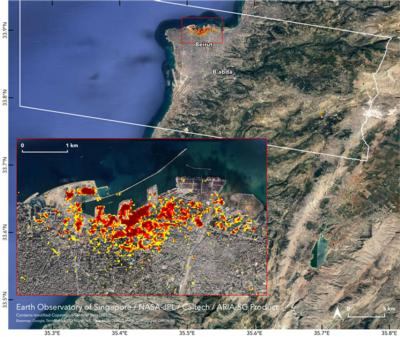
NASA's Advanced Rapid Imaging and Analysis (ARIA) team, in collaboration with the Earth Observatory of Singapore, used satellite-derived synthetic aperture radar data to map the likely extent of damage from a massive Aug. 4 explosion in Beirut.

Synthetic aperture radar data from space shows ground surface changes from before and after a major event like an earthquake. In this case, it is being used to show the devastating result of an explosion.

On the map, dark red pixels – like those present at and around the Port of Beirut – represent the most severe damage. Areas in orange are moderately damaged and areas in yellow are likely to have sustained somewhat less damage. Each colored pixel represents an area of 30 meters.

Maps like this one can help identify badly damaged areas where people may need assistance. The explosion occurred near the city's port. It claimed more than 150 lives and is estimated to have caused billions of dollars' worth of damage.

The map contains modified Copernicus Sentinel data processed by ESA (European Space Agency) and analyzed by ARIA team scientists at NASA JPL, Caltech, and Earth Observatory of Singapore. Located in Pasadena, California, Caltech manages JPL for NASA.

FMI: https://aria.jpl.nasa.gov/

Advertisement

More News

ANN's Daily Aero-Linx (06.11.25)

Aero Linx: Florida Antique Biplane Association "Biplanes.....outrageous fun since 1903." That quote really defines what the Florida Antique Biplane Association (FABA) is all about.>[...]

Airborne Affordable Flyers 06.05.25: New RV15 Wing, Scalebirds, Waiex-B Honors

Also: AV-30-C Software Upgrade, Paraglider Extremes, EarthX STC for Pitts, Vintage Aircraft Association Not only have the folks at Van’s Aircraft designed a new wing for the >[...]

Airborne-NextGen 06.10.25: Trump v Drones, Walmart-Wing, VoltAero HPU 210

Also: Skyryse Update, Ukraine Drone Attack, FAA Admin Vote, Starlink Interference Issues President Trump has signed a series of executive orders that claim to strengthen domestic d>[...]

Airborne 06.09.25: NTSB Lawsuit, Sensenich 100K, Possible DJI Ban???

Also: Snowbirds Ready!, NATA Wants Bedford, ATC Infrastructure Investment, Russia Refutes Drone Damage Alvin Brown, former Jacksonville mayor, is suing President Donald Trump after>[...]

Airborne Affordable Flyers 06.12.25: Sonex High-Wing, Stunning 'RV916', VoltAero

Also: Women’s Air Race Classic, Sensenich 100K, ‘Premature’ GAMI G100UL Motion, Quicksilver Ultralights Sonex Aircraft announced that its high-wing prototype airc>[...]

blog comments powered by Disqus


Advertisement

Advertisement

Podcasts

Advertisement

© 2007 - 2025 Web Development & Design by Pauli Systems, LC