Taranis Unveils Enhanced Platform For Aerial Imagery Insights Into Farming | Aero-News Network
Aero-News Network
RSS icon RSS feed
podcast icon MP3 podcast
Subscribe Aero-News e-mail Newsletter Subscribe

Airborne Unlimited -- Most Recent Daily Episodes

Episode Date

Airborne-Monday

Airborne-Tuesday

Airborne-Wednesday Airborne-Thursday

Airborne-Friday

Airborne On YouTube

Airborne-Unlimited-06.23.25

Airborne-NextGen-06.24.25

AirborneUnlimited-06.25.25

Airborne-AffordableFlyers-06.26.25

AirborneUnlimited-06.27.25

Thu, Mar 14, 2019

Taranis Unveils Enhanced Platform For Aerial Imagery Insights Into Farming

Debuts Holistic And Centralized Platform, Providing Advanced Actionable Insights For Clients

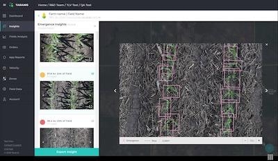
Precision agriculture solution provider Taranis has announced the launch of its updated, insights-centered platform. The company has also expanded its fleet to over one hundred manned aircrafts and autonomous drones increasing reach for customers worldwide.

By 2050, food production will have to grow by 70% to feed a growing population, and farmers and agriculture retailers are demanding tools that can help them glean insights into how to improve their yields. Taranis has developed the leading platform for aerial imagery insights for agriculture, utilizing deep-learning technology combined with high-speed UAVs and manned aircrafts to enable farmers to predict and prevent threats to over 20 million acres of crops on a granular level, such as identifying an actual type of insect on a singular leaf. These unprecedented insights help farmers to better manage crops around seed emergence, weeds, insect damage, nutrition deficiency, fertilizer top and side dressing, yield estimation, harvest priority and automated scouting.

The solution merges the benefits from its existing platform with the capabilities of Mavryx's aerial imagery platform-- a company acquired by Taranis in 2018. This includes insights from Taranis' AI2 (sub millimeter imagery samples) and UHR (high resolution full field imagery to recognize problematic zones), combined with other industry-standard technologies like satellite images and weather forecasts. Taranis' updated platform presents farmers with clear, summarized insights in real-time, enabling them to make quick decisions, rather than necessitating them to dig through layers of extraneous information.

"There is an enormous demand among farmers, and even leading agriculture retailers, for new technologies that can help streamline and improve the food production process," says Ofir Schlam, CEO of Taranis. "But those technologies can be complex to understand, and even harder to use. We hope that by bringing all of Taranis' easy-to-use products and offerings under one roof, we can provide farmers with a better way to monitor their fields, allowing them to make informed decisions and act on them quickly."

The company's enhanced platform is streamlined for the hierarchy and work flow of the farming retail chain and will seamlessly integrate with Taranis' partner companies, such as John Deere and Veris. Since the company's inception, Taranis has made huge advancements in precision agriculture technology, striving to provide farmers with the best solutions, solving issues from the first step of farming – emergence – all the way to personalized prescriptions for crop threats.

(Image provided with Taranis news release)

FMI: www.taranis.ag

Advertisement

More News

ANN's Daily Aero-Linx (06.29.25)

Aero Linx: Transport Canada We are a federal institution, leading the Transport Canada portfolio and working with our partners. Transport Canada is responsible for transportation p>[...]

ANN's Daily Aero-Term (06.29.25): Gross Navigation Error (GNE)

Gross Navigation Error (GNE) A lateral deviation from a cleared track, normally in excess of 25 Nautical Miles (NM). More stringent standards (for example, 10NM in some parts of th>[...]

Classic Aero-TV: Anticipating Futurespace - Blue Origin Visits Airventure 2017

From AirVenture 2017 (YouTube Edition): Flight-Proven Booster On Display At AirVenture… EAA AirVenture Oshkosh is known primarily as a celebration of experimental and amateu>[...]

NTSB Final Report: Cirrus SR22

Aircraft Parachute System (CAPS) Was Deployed About 293 Ft Above Ground Level, Which Was Too Low To Allow For Full Deployment Of The Parachute System Analysis: The day before the a>[...]

Airborne Affordable Flyers 06.26.25: PA18 Upgrades, ‘Delta Force’, Rhinebeck

Also: 48th Annual Air Race Classic, Hot Air Balloon Fire, FAA v Banning 100LL, Complete Remote Pilot The news Piper PA-18 Super Cub owners have been waiting for has finally arrived>[...]

blog comments powered by Disqus


Advertisement

Advertisement

Podcasts

Advertisement

© 2007 - 2025 Web Development & Design by Pauli Systems, LC