Thu, Sep 25, 2014
DARPA Designing Advanced Sensors For Military Helicopters
Degraded visibility—which encompasses diverse environmental conditions including severe weather, dust kicked up during takeoff and landing and poor visual contrast among different parts of terrain—often puts both the safety and effectiveness of tactical helicopter operations at risk. Current sensor systems that can provide the necessary visualization through obscurants struggle with latency and are too large, heavy and power-intensive to comply with military rotary wing operations.
DARPA’s Multifunction RF (MFRF) program seeks to overcome these challenges and enhance the survivability and combat effectiveness of helicopters facing degraded visibility. The program aims to develop multifunction sensor technology that would enable sensor packages small, light and efficient enough for installation on existing and future helicopter designs. MFRF would enable pilots to:
- Take off, fly and land safely in degraded and zero-visibility conditions
- Avoid collisions with other aircraft, terrain and man-made obstacles (e.g. power lines)
- Improve target detection, identification and engagement
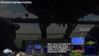
MFRF completed successful flight demonstrations on a UH-60L Black Hawk combat helicopter to demonstrate the Synthetic Vision Avionics Backbone (SVAB) technology portion of the program. The SVAB technology demonstration fused millimeter-wave radar with multiple terrain databases and onboard platform navigation to create high-resolution 2-D and 3-D visualizations of local environmental conditions. Pilots referred to the visualizations in real time to distinguish terrain features (slope, roughness, landing suitability), detect objects in a landing zone, detect and avoid obstacles, and navigate in GPS-denied conditions. The software architecture of the SVAB also demonstrated plug-and-play sensor control and display.
“These successful tests take us closer to future cost-effective, ‘plug-and-play’ systems that would improve situational awareness and mission effectiveness for manned and unmanned platforms alike,” said Bruce Wallace, DARPA program manager.
(Image provided by DARPA)
More News
He Attempted To Restart The Engine Three Times. On The Third Restart Attempt, He Noticed That Flames Were Coming Out From The Right Wing Near The Fuel Cap Analysis: The pilot repor>[...]
Make Sure You NEVER Miss A New Story From Aero-News Network Do you ever feel like you never see posts from a certain person or page on Facebook or Instagram? Here’s how you c>[...]
From 2009 (YouTube Edition): Leading Air Show Performers Give Their Best Advice for Newcomers On December 6th through December 9th, the Paris Las Vegas Hotel hosted over 1,500 air >[...]
Aero Linx: NASA ASRS ASRS captures confidential reports, analyzes the resulting aviation safety data, and disseminates vital information to the aviation community. The ASRS is an i>[...]
“For our inaugural Pylon Racing Seminar in Roswell, we were thrilled to certify 60 pilots across our six closed-course pylon race classes. Not only did this year’s PRS >[...]
 NTSB Final Report: Rutan Long-EZ

