Wed, Oct 05, 2005
UAV Gets New Sensor Suite
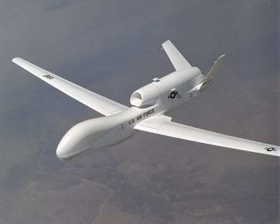
Northrop Grumman Corporation says it has completed acceptance
testing of the first production version of a new integrated sensor
suite that will enhance imaging capability for the US Air Force.
The milestone clears the way for the company to begin installing
the improved sensor package, which includes electro-optical and
infrared cameras and synthetic aperture radar, on its RQ-4A Global
Hawk air vehicles.

Raytheon Space & Airborne Systems produces the sensor
package for Northrop Grumman's Global Hawk program.
"The installation of this new sensor package on Global Hawk is a
significant milestone for the program," said George Guerra,
Northrop Grumman's Air Force Global Hawk program manager. "The
imagery provided by this sensor, even under the worst imaginable
environmental conditions on the ground, will go a long way in
meeting the needs of the warfighter."
The new sensor package features improvements derived from
technology developed and used on the U-2 program. Its new imaging
modes are improved from the current Global Hawk sensor suite, which
drew praise during Operation Iraqi Freedom for its ability to "see"
potential targets and help guide allied troop movements through
blinding sandstorms. Northrop Grumman expects to accept several
more production sensor suites from Raytheon later this year.

Two RQ-4A Global Hawks with the new production sensor suites are
ready to deploy this fall in the global war on terrorism.
With more than 4,500 hours flown in combat, Global Hawk has
provided thousands of quality images directly to battlefield
commanders during Operations Enduring Freedom and Iraqi Freedom.
The new sensor package will allow warfighters to receive better
imagery from Global Hawk than ever before.
Global Hawk flies autonomously at an altitude of at least 60,000
feet, above inclement weather and prevailing winds for more than 35
hours. During a single mission, it provides detailed intelligence,
surveillance and reconnaissance information in near-real time over
40,000 square miles - an area approximately the size of
Illinois.
More News
Aero Linx: The American Society of Aerospace Medicine Specialists (ASAMS) The Society is a non-profit organization created to serve as a voice for and represent the professional ne>[...]
Class C Service This service provides, in addition to basic radar service, approved separation between IFR and VFR aircraft, and sequencing of VFR aircraft, and sequencing of VFR a>[...]
Have A Story That NEEDS To Be Featured On Aero-News? Here’s How To Submit A Story To Our Team Some of the greatest new stories ANN has ever covered have been submitted by our>[...]
Also: ERAU Uses UAVs, P550 Group 2 UAS, Starship’s Florida Launches, NASA Missions Chopped The Air Force has put out a call to commission a one-to-one copy of the Iranian-des>[...]
Classic Klyde Morris From 11.07.16 (and Remembering Bob...) FMI: www.klydemorris.com>[...]
 ANN's Daily Aero-Linx (08.27.25)
 ANN's Daily Aero-Term (08.27.25): Class C Service
 ANN FAQ: Submit a News Story!
 Airborne-NextGen 08.26.25: Iran UAV Knockoffs, X-37B Spaceplane, Army Training
 Classic Klyde Morris (08.25.25)


