ANN's Daily Aero-Tips (08.01.06): Satellite View | Aero-News Network
Aero-News Network
RSS icon RSS feed
podcast icon MP3 podcast
Subscribe Aero-News e-mail Newsletter Subscribe

Airborne Unlimited -- Most Recent Daily Episodes

Episode Date

Airborne-Monday

Airborne-Tuesday

Airborne-Wednesday Airborne-Thursday

Airborne-Friday

Airborne On YouTube

Airborne-Unlimited-05.06.24

Airborne-NextGen-05.07.24

Airborne-Unlimited-05.08.24 Airborne-FlightTraining-05.09.24

Airborne-Unlimited-05.10.24

Tue, Aug 01, 2006

ANN's Daily Aero-Tips (08.01.06): Satellite View

Aero-Tips!

A good pilot is always learning -- how many times have you heard this old standard throughout your flying career? There is no truer statement in all of flying (well, with the possible exception of "there are no old, bold pilots.")

Aero-News has called upon the expertise of Thomas P. Turner, master CFI and all-around-good-guy, to bring our readers -- and us -- daily tips to improve our skills as aviators. Some of them, you may have heard before... but for each of us, there will also be something we might never have considered before, or something that didn't "stick" the way it should have the first time we memorized it for the practical test.

Look for our daily Aero-Tips segments, coming each day to you through the Aero-News Network.

Aero-Tips 08.01.06

One tool useful in making a broad go/no-go decision is the satellite view. Radar shows precipitation, but satellite pictures show more extensive cloud cover even away from rain or snow.

There are actually three types of satellite view -- the visible cloud cover chart, the infrared satellite view, and the water vapor imagery.

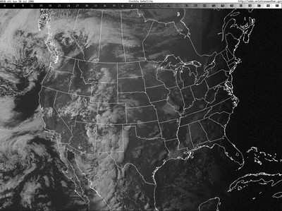
The visible cloud cover chart is just that -- a photograph from space that shows areas of cloud cover. The brighter the cloud image the higher the cloud tops, which may correlate to thunderstorms but may also depict harmless high cirrus clouds.

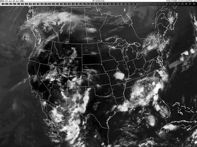
Note the eastern part of the U.S. appears dark-it's after sunset in the east, so there's no sunlight to reflect off the cloud tops and the picture is about meaningless. All is not lost-there's also an infrared view for nighttime imagery. The infrared is available both in black and white and color.

Look at New York State in the visible and infrared images -- what looks benign on the nighttime satellite chart in instead potentially hazardous on the infrared. Look also in the area near St. Louis, Missouri, and you'll see that, in daylight, the visible and infrared images correlate closely.

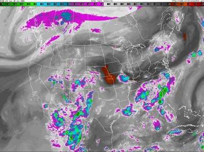
The water vapor image takes this a step further, graphically showing where the air is its wettest, giving the highest potential for storms or extensive cloudiness.

Remember that moist air cooling at night can create low clouds and poor visibility in fog. The area west of Missouri's high clouds shows a lot of moisture, for instance -- pointing to possible evening storms or reduced visibility as the evening air cools and promotes condensation.

Note that on all satellite views you're seeing the tops of the highest layer of clouds or vapor... not what lies underneath. Taken together, they show areas of extensive cloudiness, the possibility of storms and, perhaps most notably, the availability of abundant moisture that may develop into clouds, fog or storms.

Aero-tip of the day: Supplement your preflight self-brief with a look at the visible and infrared satellite images, and the water vapor imagery.

FMI: Aero-Tips

Advertisement

More News

Airborne-Flight Training 05.09.24: ERAU at AIAA, LIFT Diamond Buy, Epic A&P

Also: Vertical Flight Society, NBAA Maintenance Conference, GA Honored, AMT Scholarship For the first time, students from Embry-Riddle’s Daytona Beach, Florida, campus took t>[...]

ANN's Daily Aero-Term (05.07.24): Hazardous Weather Information

Hazardous Weather Information Summary of significant meteorological information (SIGMET/WS), convective significant meteorological information (convective SIGMET/WST), urgent pilot>[...]

Aero-News: Quote of the Day (05.07.24)

"The need for innovation at speed and scale is greater than ever. The X-62A VISTA is a crucial platform in our efforts to develop, test and integrate AI, as well as to establish AI>[...]

NTSB Final Report: Cessna 150

(FAA) Inspector Observed That Both Fuel Tanks Were Intact And That Only A Minimal Amount Of Fuel Remained In Each Analysis: According to the pilot, approximately 8 miles from the d>[...]

Aero-News: Quote of the Day (05.08.24)

“Pyka’s Pelican Cargo is unlike any other UAS solution on the market for contested logistics. We assessed a number of leading capabilities and concluded that the Pelica>[...]

blog comments powered by Disqus


Advertisement

Advertisement

Podcasts

Advertisement

© 2007 - 2024 Web Development & Design by Pauli Systems, LC