Includes SafeTaxi, Smart Airspace, And AOPA Airport
Directory
We promised our readers some BIG avionics news today... and
seldom does it get bigger than this.
Garmin International told Aero-News FIRST Thursday (we love
saying that...) about its latest cool and useful gadget -- the
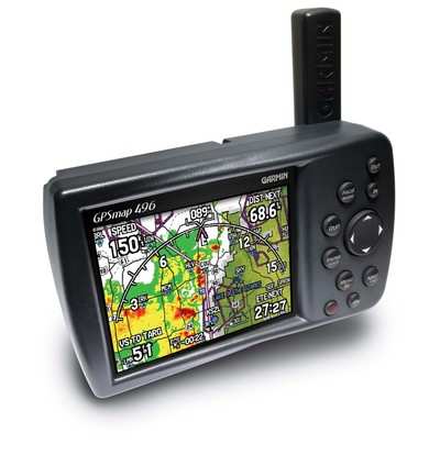
GPSMAP 496, a full-color, portable aviation device that expands on
the GPSMAP 396's features by incorporating Garmin's SafeTaxi
airport diagrams, Garmin's Smart Airspace, AOPA's Airport Directory
data, enhanced high-resolution terrain database, aviation database
with private airports and heliports, accelerated GPS update rate,
and pre-loaded automotive maps of North America or Europe.
 These features are in
addition to the real-time XM WX Satellite Weather, that puts
weather information where it's needed most -- in the cockpit, at
the pilot's fingertips.
These features are in
addition to the real-time XM WX Satellite Weather, that puts
weather information where it's needed most -- in the cockpit, at
the pilot's fingertips.
"With more power and information than any other portable
handheld on today's market, the GPSMAP 496 is an essential piece of
equipment for any pilot," said Gary Kelley, Garmin's vice president
of marketing. "The information on this mini-MFD helps increase
safety and situational awareness during all phases of flight - from
taxiing to navigating around terrain and weather. And thanks to the
pre-loaded street maps, it also gives pilots the ability to
navigate unfamiliar roadways with the same ease that they navigate
the airways."
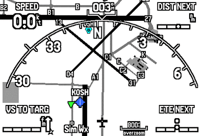
The Garmin SafeTaxi airport diagrams help pilots navigate
unfamiliar airports with confidence. Over 650 U.S. airport diagrams
come pre-loaded on the unit. The charts identify runways, taxiways,
and hangars, as well as the aircraft's exact location on the field.
Garmin anticipates offering SafeTaxi updates regularly.
International airport diagrams will also be available in the
future.
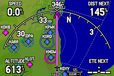
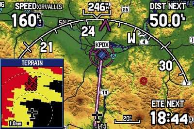
When in the air, Garmin's new Smart Airspace feature makes it
easier than ever to identify what airspace lies ahead. Smart
Airspace automatically highlights airspace close to the pilot's
current altitude and de-emphasizes airspace away from the current
altitude, which gives pilots increased situational awareness.
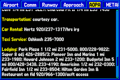
The Aircraft Owners and Pilots Association (AOPA) Airport
Directory data are also available in electronic format on the
GPSMAP 496. Recognized throughout the industry as one of the most
comprehensive sources of airport information, the AOPA's Airport
Directory includes information for over 5,300 public-use airports
and more than 7,000 FBOs, such as pilot services, ground
transportation, lodging, restaurants, and local attractions. In
addition, Garmin's version of the AOPA's Airport Directory
highlights airports where pilots can save on fuel by using
self-service fueling locations.
In addition, the GPSMAP 496 has an enhanced, higher resolution
terrain database that has over ten times as much data as the GPSMAP
396's terrain database. The new database lets pilots see vivid
depictions of proximity hazards that require their attention.
Pilots can customize their own minimum clearance limits to receive
terrain cautions, which pop up as digital thumbnail images.
Pilots will also appreciate the unit's increased GPS update
rate, which is five times faster than any other handheld on today's
market. This impressive new attribute results in near-real-time
updates of the aircraft's analog indicators, such as the HSI and
turn rate indicator. Viewing the GPSMAP 496's display in any light
is easy, thanks to the device's 256-color, high-resolution
(480x320-pixels) TFT display. The unit also features a USB
interface and rechargeable lithium-ion battery pack.
As with the GPSMAP 396, the GPSMAP 496 will continue to offer
optional XM WX Satellite Weather (US only) that features Next
Generation Radar (NEXRAD), Aviation Routine Weather Reports
(METARs), Terminal Aerodrome Forecasts (TAFs), Temporary Flight
Restrictions (TFRs), Lightning and Winds Aloft, and several other
important weather products to help pilots make informed
navigational decisions. The weather data may be laid directly over
the unit's Jeppesen and topographic map databases. Weather
information is delivered to the unit through Garmin's new GXM 30A
smart antenna, which is included with the GPSMAP 496.
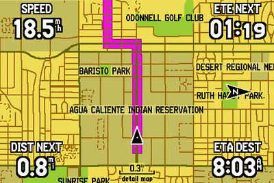
On the road, the 496 serves as a premium in-car navigation
system with automatic route calculation to any destination and
turn-by-turn voice-prompted directions along the way. The GPSMAP
496 is Garmin's first aviation handheld to include pre-loaded City
Navigator® NT maps of North America or Europe. These detailed
street maps include a huge points of interest database - including
hotels, restaurants, gas stations, ATMs, and attractions. Map data
are provided by NAVTEQ - a world leader in premium-quality
mapping.
When traveling by water, the GPSMAP 496 is compatible with
Garmin's new BlueChart g2 technology. These optional data cards
turn the GPSMAP 496 into a color chartplotter that displays
integrated marine maps with shaded depth contours, port plans,
inter-tidal zones, spot soundings, wrecks, navaids, restricted
areas, cable areas, and anchorages.
Garmin reports tThe GPSMAP 496 will be available for purchase at
EAA AirVenture 2006 in Oshkosh, WI. The expected street price is
$2,795, which includes a GXM 30A XM smart antenna, yoke mount,
cigarette-lighter adapter, AC adapter cable, USB-to-PC interface
cable, low-profile remote GPS antenna, carrying case, free Jeppesen
update certificate, City Navigator North America software, owner's
manual and quick-reference guide.
For those unable to attend EAA AirVenture or those who want to
try and win a GPSMAP 496, Garmin is also giving one away on its blog. All entries must be received
from July 20 through August 4, 2006.

For customers in Europe, Garmin also offers a GPSMAP 496
Atlantic version that will be available shortly after the GPSMAP
496 North America model is available. The GPSMAP 496 Atlantic will
include pre-loaded City Navigator Europe street maps, as well as
VFR Reporting Points (VRPs), private airports, and obstacles. The
GPSMAP 496 Atlantic does not include XM support, AOPA's Airport
Directory, or SafeTaxi diagrams.
XM WX Satellite Weather data and audio are provided by XM
Satellite Radio.
 ANN's Daily Aero-Term (05.07.25): Terminal Radar Service Area

