Fri, Feb 21, 2014
Updated Version For iOS Devices Incorporates 3D Topographic Landscape To Display
Like a number of their competitors before them, Garmin has announced an updated version of the Garmin Pilot application for the iPad and iPhone featuring synthetic vision as an option for premium subscribers. 3D Vision incorporates GPS-derived airspeed, altitude, and vertical speed overlaid on rich 3D topographic landscape. 3D Vision is transformed when optionally paired with the GDL 39 3D, which superimposes back-up aircraft attitude information overtop the Garmin SVX display.
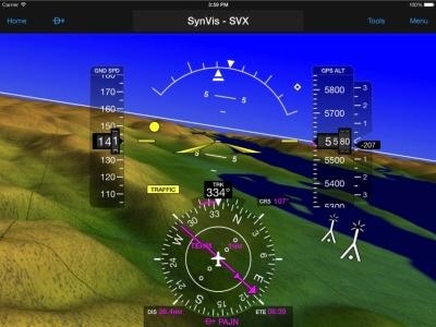
Garmin Pilot incorporates sophisticated graphics modeling to create a virtual topographic landscape. Instead of a blue-over-brown display, pilots will see an in-depth perspective view of realistic terrain features rising into the sky. Garmin Pilot conveniently displays a clear 3D depiction of ground and water features, as well as obstacles, traffic, and the runway environment. Adding to situational awareness, GPS-derived airspeed, altitude, and vertical speed are superimposed. Offering course information when an active flight plan is present, a horizontal situation indicator (HSI) is also overlaid on the 3D display. Additionally, estimated time enroute (ETE), distance information, and the active leg of a flight plan are conveniently displayed just below the HSI.
Pitch and roll information is available on the synthetic vision page when pilots use the GDL 39 3D in conjunction with Garmin Pilot. Aircraft attitude information is also displayed on the aircraft panel page, enabling pilots to view weather and traffic information alongside rich, interactive moving map information, simultaneously.
When Garmin Pilot is paired with the GDL 39 3D additional benefits include Flight Information Service-Broadcast (FIS-B) subscription-free weather, which offers NEXRAD imagery, METARs, TAFs, and more. Traffic Information Service-Broadcast (TIS-B) also helps pilots gain a better understanding of the traffic picture around them. The GDL 39 3D features TargetTrend relative motion tracking, which offers pilots a more intuitive way of judging target trajectories and closure rates in dense traffic environments. SURF technology supports the display of ADS-B-equipped surface targets on the moving map page, which offers pilots better situational awareness on runway and taxiway surfaces. The GDL 39 3D supplies highly accurate WAAS GPS data to Bluetooth compatible devices, ensuring precise position information is displayed while in-flight.
(Image provided by Garmin)
More News
We're Everywhere... Thanks To You! Even with the vast resources and incredibly far-reaching scope of the Aero-News Network, every now and then a story that should be reported on sl>[...]
“The Coast Guard anticipates new aircraft procurements may be based off Sikorsky’s MH-60R aircraft, which is the maritime variant of the H-60 in active production. Diff>[...]
Aero Linx: Classic Jet Aircraft Association (CJAA) The CJAA Formation and Safety Team (FAST) Mission is to be the sole authorized provider of formation training and certification f>[...]
During A Low Pass Over A Gravel Bar, The Airplane’S Tailwheel Impacted An Area Of Rough, Uneven Terrain Analysis: The pilot reported that he was flying low-level over various>[...]
Hold For Release Used by ATC to delay an aircraft for traffic management reasons; i.e., weather, traffic volume, etc. Hold for release instructions (including departure delay infor>[...]
 ANN FAQ: How Do I Become A News Spy?

