Airbus Successfully Launches New Sentinel-2C Satellite | Aero-News Network
Aero-News Network
RSS icon RSS feed
podcast icon MP3 podcast
Subscribe Aero-News e-mail Newsletter Subscribe

Airborne Unlimited -- Most Recent Daily Episodes

Episode Date

Airborne-Monday

Airborne-Tuesday

Airborne-Wednesday Airborne-Thursday

Airborne-Friday

Airborne On YouTube

Airborne-Unlimited-01.13.25

Airborne-NextGen-01.14.25

Airborne-Unlimited-01.15.25

Airborne-FltTraining-01.16.25

Airborne-Unlimited-01.17.25

Wed, Sep 11, 2024

Airbus Successfully Launches New Sentinel-2C Satellite

Device Will Replace Previous Models for Environmental Observation

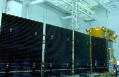
An Airbus-built Copernicus Sentinel-2C satellite was successfully launched on September 5. It will join the Copernicus constellation working to identify and monitor several changes on the ground.

The Sentinel-2C, which launched on a Vega rocket from Kourou, French Guiana, is a part of the Copernicus mission. This is the Earth Observation sector of the EU Space Programme and is managed under the European Commission (EC) and European Space Agency (ESA) partnership. It provides remote sensing of Earth, assisting in environmental observation and sustainability.

The latest satellite was on board Arianespace’s final Vega rocket. The new Vega C version will be used moving forward.

“This launch gives the world another important sensor to monitor our changing planet and provides crucial continuity since the first Sentinel-2 satellite launch in 2015,” stated Marc Steckling, Head of Earth Observation, Science and Exploration at Airbus. “Equipped with a high-resolution multispectral imager, the satellite will collect vital imagery for a myriad of applications from agriculture to water quality monitoring.”

The Sentinel-2C satellite will enter low Earth orbit at around 780 km upon completion of its initial testing phase. If everything checks out, it will replace the Sentinel-2A and work alongside the Sentinel-2B. They will fly on identical routes 180 degrees apart, allowing all of Earth’s surfaces to be checked out within five days.

The Sentinel-2 family is the Copernicus program’s “color version,” delivering imagery in 13 spectral bands with high resolution. These fall between the visible to short-wave infrared range on the electromagnetic spectrum. Their data is used for observing changes in land use, soil sealing, land management, agriculture, forestry, natural disasters, and humanitarian missions.

Each satellite collects 1.5 terabytes of data per day. It is currently stored on a high-capacity Mass Memory and Formatting unit, with data recording and laser-enabled downlink occurring on the EDRS SpaceDataHighway.

FMI: www.euspa.europa.eu

Advertisement

More News

Aero-News: Quote of the Day (01.16.25)

“The market demand for TBM and Kodiak continues to be resilient, benefitting from the versatility and operational efficiency of these aircraft – which is backed by Dahe>[...]

ANN's Daily Aero-Linx (01.16.25)

Aero Linx: N3N Owners and Restorers Association The N3N holds a special place in aviation history. The aircraft was both designed and built by the Naval Aircraft Factory, located o>[...]

Airborne-NextGen 01.14.25: VX4 Test, Drone v CL-415 Firefighter, Starship 7

Also: USAF Contractor Suit, Secret Service UAVs, Delta/Joby/Uber, Ferrovial Acquired Vertical Aerospace announced the testing program of its prototype VX4 took another significant >[...]

Airborne 01.13.25: Drone Smacks CL-415, $3.4M Verijet Court Loss, OSH25 Airshow

Also: Starship Threatened, SAOC Replacement, Navy Helos To CA Fires, 12 Planes Of Christmas A firefighting aircraft operating over the Palisades Fire in Los Angeles is grounded and>[...]

NTSB Prelim: Raytheon Aircraft Company C90A

Airplane Began An Un-Commanded Roll Forward And It Subsequently Struck An Unoccupied, Parked Company Raytheon Aircraft Company C90A On December 20, 2024, about 2315 Hawaii-Aleutian>[...]

blog comments powered by Disqus


Advertisement

Advertisement

Podcasts

Advertisement

© 2007 - 2025 Web Development & Design by Pauli Systems, LC