DJI Launches Public Beta Of New Geofencing System | Aero-News Network
Aero-News Network
RSS icon RSS feed
podcast icon MP3 podcast
Subscribe Aero-News e-mail Newsletter Subscribe

Airborne Unlimited -- Most Recent Daily Episodes

Episode Date

Airborne-Monday

Airborne-Tuesday

Airborne-Wednesday Airborne-Thursday

Airborne-Friday

Airborne On YouTube

Airborne-Unlimited-06.16.25

Airborne-NextGen-06.17.25

AirborneUnlimited-06.11.25

Airborne-AffordableFlyers-06.12.25

AirborneUnlimited-06.06.25

Tue, Jan 05, 2016

DJI Launches Public Beta Of New Geofencing System

Systems Available For North America And Europe

As the UAV industry faces new restrictions and concerns about where the small aircraft may and may not fly, DJI has launched a public beta version of its new geofencing system in North America and Europe.

Geospatial Environment Online (GEO) will provide drone users with up-to-date guidance on locations where flight may be restricted by regulation or raise safety or security concerns. With this major upgrade to DJI's existing geofencing system, users will have access to live information about areas temporarily restricted from flight due to forest fires, major stadium events, VIP travel and other changing circumstances. The GEO system will also show restricted areas around locations like prisons, power plants and other sensitive areas where drone flight would raise non-aviation security concerns.

To accommodate the large variety of authorized applications, GEO will allow drone operators with verified DJI accounts to self-authorize and temporarily unlock flight in some locations. Certain areas where drone flight is not allowed, such as Washington D.C., will remain as unlockable no-fly zones. Unlocking requires a DJI account verified with a credit card, debit card or mobile phone number. DJI will neither collect nor store the information, and the service is free.

The verified account is required only if a user chooses to fly in a location that might raise aviation safety or security concerns.

Use of GEO requires a drone firmware update and installation of a beta version of the DJI Go app.

Android users can directly download the APK file. Users of iOS devices can request a download of the beta app by providing an email address to flysafe@dji.com.

DJI expects to release a final version of GEO after completion of this short beta period.

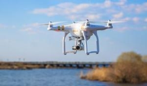
The GEO public beta will work with both DJI’s Phantom 3 and Inspire 1 drones, with specific versions available for download.

(Image provided with DJI news release)

FMI: www.dji.com/flysafe/geo-system

Advertisement

More News

DeltaHawk RV-14 Takes Flight!

New Diesel Engines On The Way for RV Builders DeltaHawk published a short video of a recent test flight using a Van’s RV-14, giving builders and buyers a hint of what’s>[...]

Airborne 06.16.25: eAircraft Symposium, MedXPress, Regent Ground Effect Aircraft

Also: Aviation Mental Health Bill, JetZero Taps NC, Radia Windrunner Avionics, Iowa Lakes Aviation Program The Vertical Flight Society announced that dozens of the world’s el>[...]

NTSB Prelim: Rockwell Commander 114A

Security Video From A Nearby Business Captured The Airplane As It Descended And Impacted Terrain On May 24, 2025, about 1658 central daylight time (CDT), a Rockwell Commander 114A >[...]

ANN's Daily Aero-Linx (06.15.25)

Aero Linx: International Auster Club Welcome to THE INTERNATIONAL AUSTER CLUB. The oldest specific aircraft type club in the United Kingdom and possibly in the world. There are cur>[...]

ANN's Daily Aero-Term (06.15.25): Waypoint

Waypoint A predetermined geographical position used for route/instrument approach definition, progress reports, published VFR routes, visual reporting points or points for transiti>[...]

blog comments powered by Disqus


Advertisement

Advertisement

Podcasts

Advertisement

© 2007 - 2025 Web Development & Design by Pauli Systems, LC