Version 2.0 Software For AV8OR Expands Capabilities | Aero-News Network
Aero-News Network
RSS icon RSS feed
podcast icon MP3 podcast
Subscribe Aero-News e-mail Newsletter Subscribe

Airborne Unlimited -- Most Recent Daily Episodes

Episode Date

Airborne-Monday

Airborne-Tuesday

Airborne-Wednesday Airborne-Thursday

Airborne-Friday

Airborne On YouTube

Airborne-Unlimited-11.10.25

AirborneNextGen-
11.11.25

Airborne-Unlimited-11.12.25

Airborne-Unlimited-11.06.25

AirborneUnlimited-11.07.25

LIVE MOSAIC Town Hall (Archived): www.airborne-live.net

Wed, Jul 28, 2010

Version 2.0 Software For AV8OR Expands Capabilities

Airport Diagrams Added For All GPS Units

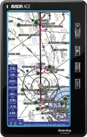
Honeywell announced Monday that a software upgrade for all AV8OR products, which allows airport diagrams on any AV8OR GPS and VFR sectionals on the AV8OR ACE.

"Pilots using the Bendix/King AV8OR are getting a product designed for future expansion,” said Roger Dykmann, director, General Aviation, Honeywell Aerospace. “VFR sectionals on the ACE will make it as invaluable a tool for VFR pilots as it has been for Instrument Flight Rules (IFR) pilots.”

Both the VFR sectional charts displayed on the AV8OR ACE, and the airport diagrams displayed on the AV8OR handheld, are geo-referenced – they feature “own ship” position, which provides greater situational awareness regarding position of the aircraft at the airport. On the AV8OR ACE, the VFR sectional charts display also includes flight plan and user configured navigation data overlay, similar to charts already available. Both scanned VFR sectional charts and airport diagrams are available via subscription and can be downloaded directly from Honeywell’s vendor. Annual subscriptions are priced at $79 for VFR sectionals and $49 for Airport Diagrams.

In addition to VFR sectional chart capability, the AV8OR ACE has been expanded to include geo-referenced Eurocontrol charts, including IFR and VFR approach plates, SIDs/STARs, Airport Diagrams and HI/LO IFR enroute charts. A first-time complete download is $99, while annual subscriptions for VFR approach plates and airport diagrams are $249 and complete VFR and IFR charts are $799.

Honeywell has also released a new IFR chart download manager for the AV8OR ACE, which allows pilots to download only the charts that have been changed since the last cycle, greatly reducing download times. Available now, the new incremental chart download capability is automatic and seamless to current AV8OR ACE users. Expanding Capability Following the initial AV8OR 2.0 release, a number of additional feature upgrades are scheduled for release this fall. These include Honeywell’s new “Portable Glass Panel” that adds a GPS-based panel page, comprising a Directional Gyro (DG) representation with graphical flight plan, rate of turn, altitude and ground speed. Additionally, split-screen capability for the ACE, XM radio and graphical weight and balance features are in development, which will provide more value to owners through quicker flight planning and more entertainment options.

FMI: www.bendixking.com/AV8OR

Advertisement

More News

ANN FAQ: Contributing To Aero-TV

How To Get A Story On Aero-TV News/Feature Programming How do I submit a story idea or lead to Aero-TV? If you would like to submit a story idea or lead, please contact Jim Campbel>[...]

Classic Aero-TV: Bob Hoover At Airventure -- Flight Test and Military Service

From 2011 (YouTube Edition): Aviation's Greatest Living Legend Talks About His Life In Aviation (Part 5, Final) ANN is pleased to offer you yet another snippet from the public conv>[...]

Aero-News: Quote of the Day (11.12.25)

“All Air Traffic Controllers must get back to work, NOW!!! Anyone who doesn’t will be substantially ‘docked. For those Air Traffic Controllers who were GREAT PATR>[...]

ANN's Daily Aero-Linx (11.12.25)

Aero Linx: American Navion Society Welcome to the American Navion Society. Your society is here to support the Navion community. We are your source of technical and operating infor>[...]

ANN's Daily Aero-Term (11.12.25): Glideslope Intercept Altitude

Glideslope Intercept Altitude The published minimum altitude to intercept the glideslope in the intermediate segment of an instrument approach. Government charts use the lightning >[...]

blog comments powered by Disqus


Advertisement

Advertisement

Podcasts

Advertisement

© 2007 - 2025 Web Development & Design by Pauli Systems, LC