Also Announces New Flitestar Version For Enhanced Weather
Data
Jeppesen introduces avionics data solutions to support leading
light sport and experimental aircraft original equipment
manufacturer (OEM) providers, including Advanced Flight Systems,
Dynon Avionics, Garmin and MGL Avionics. The avionics data offering
serves as part of a total Jeppesen light sport and experimental
aircraft solution suite for both certified and non-certified
aircraft.

For light sport and experimental aircraft avionics systems,
Jeppesen provides NavData navigation information, obstacle data and
electronic charting, in addition to aviation parts and supplies
offered through partner company Aviall. Jeppesen’s
partnerships with leading OEM providers assures light sport and
experimental aircraft pilots a secure data source for their
avionics systems and assists pilots with reducing paper in the
cockpit by transitioning to digital information solutions.
“Our experimental aircraft customers are able to customize
their avionics data display to their preference, and they expect
their data to be accurate, such as airspeed indication. Similarly,
they also expect that navigation data presented is accurate and
up-to-date,” said Matt Liknaitski, president of MGL Avionics,
U.S. “For this reason, MGL Avionics is very excited to be
able to offer the ability for our customers to select Jeppesen as a
source for their navigation data, to ensure their avionics systems
are connected to the best aviation navigation databases
onboard.”
Jeppesen Nav Data
Jeppesen provides the only true, consistent worldwide electronic
chart coverages, generated from the most extensive navigation
database available for light sport and experimental aircraft.
Jeppesen navigation data updates are available online, through the
Jeppesen Services Update Manager system.
“Jeppesen not only provides reliable navigation
information, but we also offer state of the art online training
programs to introduce the excitement of the light sport and
experimental aviation industry to a new generation of innovative
aircraft enthusiasts, ”said Scott Reagan, director, Jeppesen
OEM Client Management
The company also took the wraps off a new version of its new
FliteStar flight planning program that now includes enhanced global
weather data services on Thursday. Jeppesen FliteStar users will
now be able to improve situational awareness through receiving
continually updated weather information. Weather data is now
presented through multiple customized graphical formats displayed
according to FliteStar coverage area, user preference and flight
plan.
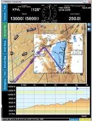
Jeppesen FliteStar Screen Shot
The company says its ground-based FliteStar version 9.5
presents users with a dynamic graphical view of the weather
environment in both enroute and profile views and reduces the need
to switch between enroute and weather displays. Jeppesen weather
data now aligns with the FliteStar coverage area purchased and
weather download overlay displays are presented on enroute charts
and are updated automatically through an Internet connection.
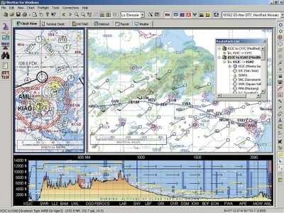
The new version of the FliteStar program provides a new tool to
view current weather at or near time of departure plus forecast
weather along a route and at a user’s planned destination.
The weather service combines current data from the National Weather
Service and other sources, including NEXRAD mosaic data and
includes critical icing and turbulence information.
“The new FliteStar version 9.5 allows our customers to
view vital weather information in a new graphical format that is
customized for the needs of individual users,” said Tim
Huegel, director, Jeppesen Aviation Portfolio Management.
“FliteStar users can now display from zero to nine graphical
weather elements simultaneously and are assured of receiving the
same world-class quality of reliable weather data from Jeppesen
that they have come to expect from the past 25 years of our
FAA-validated weather data service.”
Weather elements included in the new FliteStar version includes
AIRMETs, SIGMETs, radar, lighting, surface analysis, METARs, icing,
turbulence and wind data. A new weather toolbar gives users the
ability to display or close these graphical elements, according to
user preference. A new “chart time slider” feature
allows users to view current weather for the flight plan and a new
“weather legend” graphical element shows all currently
displayed weather elements. An “icing” display bar
allows users to formulate an ice-avoidance strategy and flight plan
before leaving the ground.
FMI: www.jeppesen.com
 ANN's Daily Aero-Term (05.05.25): Circle To Runway (Runway Number)

