Voyager FPS and ANN Bring YOU The Weather In Oshkosh For Thursday 07.20.06 | Aero-News Network
Aero-News Network
RSS icon RSS feed
podcast icon MP3 podcast
Subscribe Aero-News e-mail Newsletter Subscribe

Airborne Unlimited -- Most Recent Daily Episodes

Episode Date

Airborne-Monday

Airborne-Tuesday

Airborne-Wednesday Airborne-Thursday

Airborne-Friday

Airborne On YouTube

Airborne-Unlimited-06.23.25

Airborne-NextGen-06.24.25

AirborneUnlimited-06.25.25

Airborne-AffordableFlyers-06.26.25

AirborneUnlimited-06.27.25

Thu, Jul 20, 2006

Voyager FPS and ANN Bring YOU The Weather In Oshkosh For Thursday 07.20.06

As Provided By Seattle Avionics And ANN!

We're gonna help you get to the fabled land of Oshkosh... with a little help from our friends!

In conjunction with our friends at Seattle Avionics, Aero-News will be offering a Travel Update on our homepage, as well as for readers of our daily Propwash newsletter, throughout AirVenture 2006.

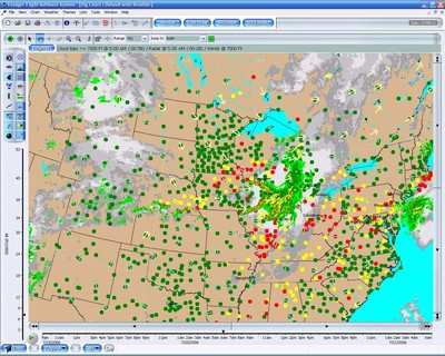
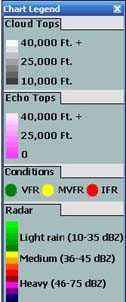
The graphic image, updated every morning, will show TFRs, radar, cloud cover, winds aloft, and other data... all appearing on a chart similar to what you'll find in Seattle Avionics' Voyager FreeFlight software.

What's more, you can customize this image to display whatever YOU want to show!

Traveling To Oshkosh?

This morning's weather report and airspace update are shown updated at 7:00 AM EDT 07.20.06.


DUAT WEATHER

SYNOPSIS...10Z SURFACE LOW CENTRAL IA. COLD FRONT ACROSS NORTHEASTERN KS TO EASTERN CO. WRMFRONT FROM LOW ACROSS MID KY. HIGH CENTER ND. AIR MASS VERY MOIST AND UNSTABLE ALONG FRONTS. LOW MOVING TO SOUTHERN INDIANA WITH COLD FRONT SW THROUGH SOUTHERN MO BECMG STATIONARY FRONT E/W ACROSS SOUTHERN KS CURVING NORTHWEST TO LOW OVER SOUTHEAST WY. HIGH PRESSURE NORTHERN ND THROUGH LS.


WI NORTHWEST HALF...ABOVE GROUND LEVEL SCATTERED 3/8-4/8 COVERAGE AT 5000 FT BROKEN 5/8-7/8 COVERAGE AT 15000 FT TOP FL250. VIS 3-5SM MIST. ISOL LIGHT THUNDERSTORM RAIN. CUMULONIMBUS TOP FL400. 14Z ABOVE GROUND LEVEL SCATTERED 3/8-4/8 COVERAGE AT 5000 FT SCATTERED CIRRUS. OUTLOOK...VFR. SOUTHEAST HALF...ABOVE GROUND LEVEL SCATTERED 3/8-4/8 COVERAGE AT 2000 FT CEILING BROKEN 5/8-7/8 COVERAGE AT 4000 FT OVERCAST AT 10000 FT TOP FL280. VIS 3-SM MIST. SCATTERED THUNDERSTORM RAIN POSS SEVERE. CUMULONIMBUS TOP ABOVE FL450. 15Z ABOVE GROUND LEVEL SCATTERED 3/8-4/8 COVERAGE AT 5000 FT SCATTERED 3/8-4/8 COVERAGE-BROKEN 5 /8-7/8 COVERAGE AT 15000 FT. ISOL LIGHT SHOWER(S) OF RAIN. 18Z ABOVE GROUND LEVEL SCATTERED 3/8-4/8 COVERAGE AT 5000 FT. OUTLOOK...VFR.


Pretty cool, eh? But wait... it gets even better. In addition to displaying this information on the Aero-News website... Seattle Avionics is also offering a special,FREE version of Voyager FreeFlight for ANN readers to download for their personal use.

For an up-to-the-minute look at the weather, airspace, and airport data for your flight, be sure to download your 100% FREE version of Voyager FreeFlight Flight Planner, courtesy of Aero-News. Use it for your flight to Oshkosh... and for your flights to come!

FMI: Download Your ANN FreeFlight Flight Planner Here

Advertisement

More News

NTSB Prelim: Piper PA-23

Pilot Also Reported That Due To A Fuel Leak, The Auxiliary Fuel Tanks Were Not Used On June 4, 2025, at 13:41 eastern daylight time, a Piper PA-23, N2109P, was substantially damage>[...]

ANN FAQ: Submit a News Story!

Have A Story That NEEDS To Be Featured On Aero-News? Here’s How To Submit A Story To Our Team Some of the greatest new stories ANN has ever covered have been submitted by our>[...]

Classic Aero-TV: One Man’s Vietnam

From 2023 (YouTube Edition): Reflections on War’s Collective Lessons and Cyclical Nature The exigencies of war ought be colorblind. Inane social-constructs the likes of racis>[...]

ANN's Daily Aero-Linx (07.03.25)

Aero Linx: Colorado Pilots Association (CPA) Colorado Pilots Association was incorporated as a Colorado Nonprofit Corporation in 1972. It is a statewide organization with over 700 >[...]

ANN's Daily Aero-Term (07.03.25): High Speed Taxiway

High Speed Taxiway A long radius taxiway designed and provided with lighting or marking to define the path of aircraft, traveling at high speed (up to 60 knots), from the runway ce>[...]

blog comments powered by Disqus


Advertisement

Advertisement

Podcasts

Advertisement

© 2007 - 2025 Web Development & Design by Pauli Systems, LC