 At a "Top Secret" meeting between
ANN and Garmin officials several week as ago, ANN Staffers Jim
Campbell and James Grosser were among the first of the"outside"
world to see two new developments from the ever-inventive folks at
Garmin. We unveiled our exclusive first look at the Garmin G3000
Next-Gen Flight Deck at the start of NBAA 2009, and now we're
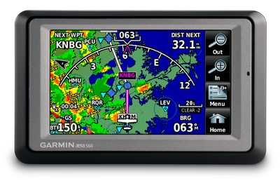
pleased to take the wraps off Garmin's latest GPS Portable -- the
aera... a device that makes heavy use of one of the technologies
that Garmin has excelled in developing... Touchscreen Displays.
At a "Top Secret" meeting between
ANN and Garmin officials several week as ago, ANN Staffers Jim
Campbell and James Grosser were among the first of the"outside"
world to see two new developments from the ever-inventive folks at
Garmin. We unveiled our exclusive first look at the Garmin G3000
Next-Gen Flight Deck at the start of NBAA 2009, and now we're
pleased to take the wraps off Garmin's latest GPS Portable -- the
aera... a device that makes heavy use of one of the technologies
that Garmin has excelled in developing... Touchscreen Displays.
Garmin's newest aviation handheld series offers touchscreen and
multi-mode capabilities so that it can transition between aviation
to automotive mode with one touch. The aera series includes four
different models - aera 500, aera 510, aera 550 and aera 560 - and
all have unprecedented ease of use that is derived from Garmin's 20
years of expertise in the aviation and automotive markets. The aera
product line will be on display and available for purchase for the
first time at the upcomign AOPA event in Tampa, Florida, November
5-7, 2009.
"Customers who use Garmin products in their plane and car often
ask us to create an all-in-one GPS that combines our aviation
expertise with the operational simplicity and clean exterior design
of our automotive devices," said Gary Kelley, Garmin's vice
president of marketing. "Since Garmin is vertically integrated and
we do nearly everything in-house, we were able to meet our
customers' requests by leveraging the best features of our consumer
and aviation technologies. The aera series will appeal to those who
need a low cost aviation handheld that is so simple to use that
many will never have to crack open the manual."
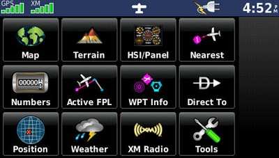
The aera series has a 4.3 inch QVGA sunlight readable
touchscreen display with large, finger-touchable icons. When in
aviation mode, pilots are greeted with colorful icons that use
intuitive pictures and labels to indicate their function: map,
weather, terrain, direct to, HSI/panel, active FPL, numbers,
nearest, WPT info, position, XM radio, and tools. Pilots can choose
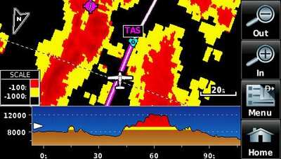
any of these functions by simply touching the appropriate icon. For
example, after touching the terrain icon, pilots will see terrain
and obstacle data that vividly depicts potential hazards.
The exterior of the aera 500, 510, 550 and 560 are identical,
but the software features of each model are tailored to those
seeking an entry or mid-level aviation handheld.
|
|
aera 500
|
aera 510
|
aera 550
|
aera 560
|
|
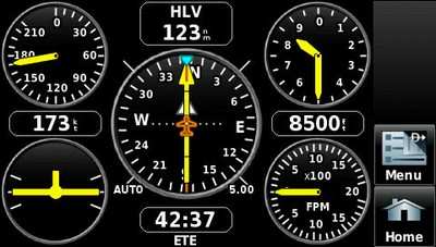
5 HZ GPS update rate for near-real-time updates of panel
page
|
X
|
X
|
X
|
X
|
|
Patented aviation panel page
|
X
|
X
|
X
|
X
|
|
Terrain and obstacle data
|
X
|
X
|
X
|
X
|
|
Private Airport data
|
X
|
X
|
X
|
X
|
|
XM WX capable and GXM™ 40 antenna included (XM WX
subscription required)
|
|
X
|
|
X
|
|
Standard 30 arc second terrain/obstacle data
|
X
|
X
|
|
|
|
High resolution 9 arc second terrain/obstacle data for a more
vivid depiction of proximity hazards (over 11 times more onscreen
resolution than the standard 30 arc-second)
|
|
|
X
|
X
|
|
SafeTaxi® with over 950 US airports
|
|
|
X
|
X
|
|
AOPA Airport Directory
|
|
|
X
|
X
|
|
One year complimentary aviation database updates (obstacles,
terrain, SafeTaxi, NavData and AOPA Airport Directory)
|
|
|
X
|
X
|
|
Preloaded auto maps with voice prompted directions that speak
street names, “turn right on main street”
|
X
|
X
|
X
|
X
|
|
Bluetooth capability in automotive mode
|
X
|
X
|
X
|
X
|
|
Ruggedized and waterproof (IEC 529 IPX-7 standards)
|
X
|
X
|
X
|
X
|
|
Enhanced auto features (lane assist, junction view, and speed
limit notification)
|
|
|
X
|
X
|
|
NAVTEQ automotive traffic compatible (requires purchase of
accessory cigarette lighter adapter with integrated FM traffic
receiver)
|
|
|
X
|
X
|
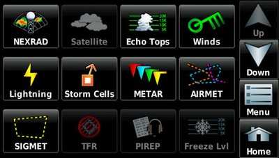
The aera 510 and aera 560 include a GXM 40 receiver for XM radio
and XM WX Satellite Weather that provides NEXRAD weather radar,
aviation routine weather reports (METARs), terminal aerodrome
forecasts (TAFs), temporary flight restrictions (TFRs), lightning,
winds aloft, turbulence forecasts, PIREPs, icing forecast and
several other important weather products.
The aera 550 and area 560 include SafeTaxi and AOPA Airport
Directory. SafeTaxi now includes geo-referenced diagrams of over
950 U.S. airports. SafeTaxi identifies runways, taxiways and
hangars, as well as the aircraft's exact location on the field. The
AOPA Airport Directory data is an electronic version of AOPA's
popular U.S. pilot guide that includes information for over 5,300
public-use airports and more than 7,000 FBOs, such as pilot
services, ground transportation, lodging, restaurants, and local
attractions. In addition, Garmin's electronic version of the AOPA
Airport Directory highlights airports where pilots can save on fuel
by using self-service fueling locations.
Pilots can keep track of and renew the databases on their aera
device through fly.Garmin.com, a website that helps pilots manage
Garmin database information and dramatically simplifies the process
of updating and purchasing aviation databases such as obstacles,
terrain and SafeTaxi.
After logging onto fly.Garmin.com, the home page gives a quick
synopsis of the owner's registered products and whether or not the
databases are current. If a database needs to be updated, users can
purchase one-time downloads or annual subscriptions directly from
the site and install the database in three easy steps.
Fly.Garmin.com eliminates the hassle of "unlock codes." Those
who have purchased the aera 550 or aera 560 will receive one year
complimentary aviation database updates for obstacles, terrain,
SafeTaxi, NavData and AOPA Airport Directory.
Customers can easily change from aviation to automotive mode by
pressing the airplane icon at the top of the aera's screen. In the
automotive mode, customers will see the same "Where to?" and "View
map" interface found on Garmin nüvi and zumo products. The
ruggedized and waterproof (IEC 529 IPX-7 standards) aera series
comes loaded with detailed, street-level maps of the United States,
Canada and Puerto Rico. For those who prefer two wheels over four,
the aera is also compatible with Garmin's zumo 660 motorcycle
mount. The aera allows for quick searches of street addresses or
millions of preloaded points of interest like gas stations, hotels,
restaurants, attractions, ATMs and more. In automotive mode, the
device will speak street names so drivers will receive
turn-by-turn, voice prompted directions through the aera's built-in
speaker, such as "turn right on Main Street." If they miss a turn,
the aera automatically recalculates a route and gets them back on
track.
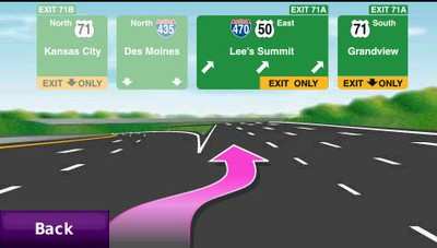
The aera 550 and 560 come equipped with advanced routing
capabilities like lane assist with junction view so drivers will
see a realistic presentation of road signs and junctions along the
route, as well as arrows that indicate the proper lane for
navigation. These features make it easy to navigate unfamiliar
intersections and exits because the aera guides drivers to the
correct lane for an approaching turn or exit. Map data is provided
by NAVTEQ - a world leader in premium-quality mapping.
The benefits of XM and XM WX Satellite Weather capability are
also available in automotive mode. While in the automotive mode,
drivers may overlay weather information along their route, as well
as simultaneously choose from XM radio's 170-plus channels of XM
digital music, news and programming. XM radio and XM WX
Satellite Weather subscription data is available from XM WX
Satellite Weather, and is only available in the U.S. or Canada.
All aera products also have Bluetooth Wireless Technology that
makes it possible to receive and place phone calls directly from
the aera while in automotive mode. It can be paired with over 200
Bluetooth enabled phones, and a driver can retrieve and dial
numbers using a supported phone's contact list, the phone's call
history log, or the aera's preloaded points of interest
database.
The aera 500, aera 510, aera 550 and aera 560 are available
immediately for an expected street price of $799, $1299, $1499, and
$1999, respectively.
 NTSB Final Report: Cozy Cub