First Flight Completed Last Week, Different Aircraft Involved This Year
NASA's Operation IceBridge, an airborne survey of polar ice, successfully completed its first Greenland research flight of 2015 on March 19, thus launching its seventh Arctic campaign. This year's science flights over Arctic sea and land ice will continue until May 22.

The mission of Operation IceBridge is to collect data on changing polar land and sea ice and maintain continuity of measurements between NASA's Ice, Cloud and Land Elevation Satellite (ICESat) missions. The original ICESat mission ended in 2009, and its successor, ICESat-2, is scheduled for launch in 2017. Operation IceBridge, which began in in 2009, is currently funded until 2019. The planned two-year overlap with ICESat-2 will help scientists validate the satellite's measurements.
The extensive data IceBridge has gathered over the Greenland ice sheet during its six years of operations have provided an improved picture of the surface, the bed and the internal structures of Greenland's ice sheet and allowed scientists to create more accurate models of glacier contribution to sea level rise. As for sea ice, IceBridge's measurements of the thickness of sea ice and its snow cover have assisted in improving forecasts for summertime melt, enhanced the understanding of variations in ice thickness distribution from year to year, and updated the climatology of the snow depth over sea ice.
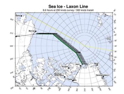
The first part of the Arctic campaign, based in the Thule Air Base in northern Greenland and including a short deployment to Fairbanks, Alaska, will focus on the sea ice in the Arctic Ocean north of Greenland and in the Beaufort and Chukchi Seas north of Alaska.
"As far as the sea ice flight lines go in the Arctic this year, the new thing is that we're not changing things this year," said Jackie Richter-Menge, IceBridge science team co-lead and sea ice researcher with the U.S. Army Corps of Engineers Cold Regions Research and Engineering Laboratory in Hanover, N.H. "We've achieved a pattern of survey flights that is doing its job: it provides good insight into what the thickness distribution of the Arctic cover looks like in the Western Arctic, late in the winter season. This coverage is good both for modelers that are looking to do a prediction of the seasonal extent of the ice cover through the following summer and it also pays a nice complement to the satellite coverage that we're getting from ESA's [European Space Agency] CryoSat-2 satellite."
This year, one of IceBridge's radar instruments, the Multi-Channel Coherent Radar Depth Sounder (MCoRDS), which is operated by the Center for Remote Sensing of Ice Sheets at the University of Kansas in Lawrence, Kansas, will try for the first time to take direct measurements of sea ice thickness. Thickness is a key indicator of Arctic sea ice's likelihood to survive the summer melt season, but remote measurements of this characteristic are largely indirect.
"It would really be a wonderful thing to get direct measurements of sea ice thickness because what we have now is an inferred measurement based on how much sea ice is floating above open water," Richter-Menge said. "Direct measurements would increase the level of certainty in the data."
The second part of the Operation IceBridge's 2015 Arctic campaign will be based in Kangerlussuaq, Greenland, and it will focus on surveying ice surface elevation and thickness at several rapidly changing points of the Greenland ice sheet. Afterward, the team will return to Thule for the last phase of the field campaign.
This year, four areas have been added to the list of Operation IceBridge's high priority missions. Among these are the Zachariae Isstrom glacier in northeast Greenland and its neighbor to the north, the 79 N or Nioghalvfjerdsbrae glacier. Both of these rivers of ice have rapidly increased the rates in which they drain land ice to the ocean in the past years.
"That part of Greenland is changing very rapidly and corresponds to a basin below sea level pretty far inland," said Eric Rignot, IceBridge science team co-lead and glaciologist at the University of California, Irvine and NASA's Jet Propulsion Laboratory (JPL) in Pasadena, California. "It's a sector that we're paying close attention to because it has the potential to change rapidly and it could have a significant implication for sea level rise in the coming decades."
"As we do every year, we are sampling the four corners of Greenland and the interior regions to complete a rather extensive survey of the ice sheet," Rignot said. "Recent results have shown that this type of survey is good enough to keep track of the total mass loss of the ice sheet from year to year, and also to get details on glaciers that are key players in driving the mass loss to higher values every year."
Operation IceBridge is using a different research aircraft this year, an adapted C-130 Hercules former military plane. The mission's usual ride in the Arctic, a P-3, is getting new wings. Despite both planes having similar sizes and capabilities, mounting IceBridge's array of lasers and radars on an unfamiliar fuselage doesn't come without challenges.
"Any time we install our very extensive suite of sensors, they have to be integrated in the aircraft, which means mechanically mounted in good, stiff mounts, and the radar antennas have to be embedded within the fuselage so that they function adequately without requiring time-consuming aerodynamic modifications to the aircraft," said John Sonntag, Operation IceBridge's Field Team Lead. "It takes a lot of time and mechanical work to get the sensors mounted on the aircraft and to get the electrical interfaces with the crew and the cockpit."
As in previous years, Operation IceBridge will be collaborating with several international research initiatives. In Barrow, Alaska, the C-130 will overfly a sea ice experiment by the Naval Research Laboratory. In a remote outpost in the northeastern Greenland coast, IceBridge will take measurements overlapping those taken from the ground by researchers from the University of Manitoba, Canada. And, weather permitting, NASA's airborne polar laboratory will fly over a drifting sea ice station in the Fram Strait, a passage between Greenland and Svalbard that is the primary region of sea ice export from the Arctic.
"The purpose of our cooperations with other research groups is to understand our own instruments better by comparison to the measurements they're collecting on the ground, primarily snow depth and sea ice thickness," Sonntag said. " We use their detailed measurements collected on the ground to better understand the geographically much wider, but in some cases less detailed measurements we take from the air."
(Images provided by NASA)
 Aero-News: Quote of the Day (11.20.25)

