Enhancements Provided For Select Helicopters
Garmin is pleased to announce new features and capabilities are now available within the GTN 650/750 touchscreen series for select helicopters currently in service.

The new features include WireAware, which graphically overlays power line location and relative altitude information on the moving map and terrain pages. Powerlines are depicted in colors corresponding to their height relative to the helicopters' altitude so it’s easy to identify powerlines that may pose a threat. If the GTN 650/750 is enabled with optional Helicopter Terrain and Awareness Warning System (HTAWS), visual and aural alerts are provided for powerlines as well as terrain and obstacle hazards. WireAware powerline database coverage currently includes the U.S., as well as portions of Canada and Mexico.
Flight plan entry and waypoint selection is now easier with FastFind, which incorporates predictive logic to suggest airports and waypoints using current GPS location. A readily accessible button displays suggested entries, saving keystrokes when entering data or looking for information.
Entering frequencies into the GTN is streamlined, which now may be entered without the leading number “1” and trailing zero(s). For example, pilots can now enter the frequency “122.8” easily into the GTN by simply selecting “2”, “2” and “8.” Because the number one and trailing zeros populate automatically, frequency entry is faster and easier. Additionally, reverse frequency lookup allows pilots to quickly observe that the correct frequency is tuned because the GTN displays the facility name adjacent to the tuned frequency.
Utilizing the Garmin Aviation Checklist Editor on a PC, pilots now have the option to create custom checklists for display on the GTN 650/750. Once created, checklists can be saved to a Garmin data card and inserted into the GTN. Optionally, flight plans and waypoints may also be created and imported into the GTN using a Garmin data card. For added convenience, flight plans can be stored in the flight plan catalog within the GTN for future use.
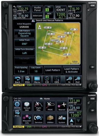
For operators conducting SAR missions, the GTN 650/750 can automatically generate flight plans using four search patterns: Parallel Line Search, Expanding Square, Orbit or Sector Search patterns.
Popular among Garmin’s Integrated Flight Deck product line, the GTN series can now overlay an optional fuel range ring on the moving map, displaying the remaining flight distance relative to the amount of fuel on board. Helicopter range until operating on reserve fuel and total endurance are displayed as a green dashed line and yellow solid line respectively. Reserve fuel times are configurable so they can be tailored to each particular flight or operation. The addition of a fuel flow sensor is required to display fuel range data.
Weather-related decision-making is easier with the GTN 650/750, which helps pilots interpret datalink radar imagery more easily by animating weather radar from different sources, including:
- GDL 88, Flight Information Service-Broadcast (FIS-B) Regional and CONUS radar imagery
- GDL 69, SiriusXM US and Canada NEXRAD radar information
- GSR 56, precipitation imagery received via Iridium
In addition, the upgrade includes:
- Configurable data fields and shortcuts located within the radio bar and on the corners of the moving map can be assigned by the pilot, providing rapid access to frequently used data and functions
- Radial/Distance display to a tuned NAV
- Support for custom scheduled messages
- Customized holds can be created over an existing fix or a user-defined waypoint
- Advisory vertical guidance for LP+V approaches
Installation approval for the GTN navigators with v6.11 software is available via AML STC, which includes the following helicopters:
- Bell 206 and Bell 407 series
- Eurocopter AS 350B2/B3, EC 130 B4, EC 130T2
- MD 369E/F/FF
New and existing customers can receive these features by contacting an authorized Garmin dealer.
(Image provided with Garmin news release)
 TikToker Arrested After Landing His C182 in Antarctica
 Classic Aero-TV: Versatile AND Practical - The All-Seeing Aeroprakt A-22 LSA
 ANN's Daily Aero-Term (06.27.25): Hazardous Weather Information
 ANN's Daily Aero-Linx (06.27.25)
 Aero-News: Quote of the Day (06.27.25)


