Mon, Sep 09, 2019
The Copernicus Satellite Will Now Undergo Extensive Testing, With Its Launch Set For November 2020
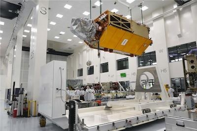
Airbus has completed the ocean satellite ‘Copernicus Sentinel-6A’, and is now sending it on its first journey. Its destination: Ottobrunn near Munich in Germany, where over the next six months the satellite will undergo an extensive series of tests at Industrieanlagen Betriebsgesellschaft mbH (IABG) to prove its readiness for space.
‘Copernicus Sentinel-6’ will carry out high-precision measurements of ocean surface topography. The satellite will measure its distance to the ocean surface with an accuracy of a few centimetres and, over a mission lasting up to seven years, use this data to map it, repeating the cycle every 10 days. It will document changes in sea-surface height, record and analyse variations in sea levels and observe ocean currents. Exact observations of changes in sea-surface height provide insights into global sea levels, the speed and direction of ocean currents, and ocean heat storage. These measurements are vital for modelling the oceans and predicting rises in sea levels.
The findings will enable governments and institutions to establish effective protection for coastal regions. The data will be invaluable not only for disaster relief organisations, but also for authorities involved in urban planning, securing buildings or commissioning dykes.
Some data suggests that global sea levels are currently rising by an average of 3.3 millimetres (0.13 inches) a year, which could potentially have dramatic consequences for countries with densely populated coastal areas.
Two Sentinel-6 satellites for the European Copernicus Programme for environment and security are currently being developed under Airbus’s industrial leadership. While it is one of the European Union’s family of Copernicus satellite missions, Sentinel-6 is also being realised thanks to an international cooperation between ESA, NASA, NOAA and Eumetsat.
Each satellite weighs approximately 1.5 metric tons. From November 2020, Sentinel-6A will be the first of the two Sentinel-6 satellites to continue collecting satellite-based measurements of the oceans’ surfaces, a task that began in 1992. Sentinel-6B is then expected to follow in 2025.
(Image provided with Airbus Space news release)
More News
Aero Linx: International Federation of Airworthiness (IFA) We aim to be the most internationally respected independent authority on the subject of Airworthiness. IFA uniquely combi>[...]
Ultrahigh Frequency (UHF) The frequency band between 300 and 3,000 MHz. The bank of radio frequencies used for military air/ground voice communications. In some instances this may >[...]
A Few Questions AND Answers To Help You Get MORE Out of ANN! 1) I forgot my password. How do I find it? 1) Easy... click here and give us your e-mail address--we'll send it to you >[...]
From 2019 (YouTube Edition): Learning To Paint Without Getting Any On Your Hands PPG's Aerospace Coatings Academy is a tool designed to teach everything one needs to know about all>[...]
Also: Sustainable Aircraft Test Put Aside, More Falcon 9 Ops, Wyoming ANG Rescue, Oreo Cookie Into Orbit Joby Aviation has reason to celebrate, recently completing its first full t>[...]
 ANN's Daily Aero-Linx (05.06.25)

