Provides Real-Time Visual Weather Information Accessible Online
As winter weather whips the nation’s northern-most state, pilots now have access to a fully deployed Alaska Weather Camera Program to help them determine when and where it’s safe to fly.
The FAA says the program improves safety and efficiency by providing pilots with near real-time, visual weather information. It includes a recently updated website that enhances navigational planning on an interactive map with easily accessible images and other weather data products.
“The completion of this program marks another milestone in our continuing commitment to aviation safety in Alaska,” said FAA Administrator Michael Huerta. “These cameras are critical in making sure that people in Alaska can get to their destination as safely as possible.”
The pictures have been critical in helping pilots in Alaska make better safety decisions. The program also helps aircraft operators save fuel by eliminating situations where pilots take off only to find they have to return due to bad weather.
More than three-quarters of Alaskan communities have no access to highways or roads and depend on aviation for access to food, mail, jobs, schools, medical services and travel. For these communities, small aircraft are essential to everyday life.
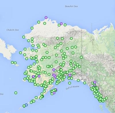
The program began in 1999. The FAA installed the 100th weather camera at Quinahak in May 2009 and the 150th at Talkeetna in 2011. Technicians installed the 221st and final weather camera in September 2014 at Harris River on Prince of Wales Island in southeast Alaska.
The cameras are positioned to view sky conditions around airports and air routes as well as extreme mountain passes such as the Anaktuvuk Pass on Alaska’s northern slope. The most remote camera site is at Misty Fiords, in the tidal zone of the Behm Canal in the Misty Fiords National Monument. It is located approximately 52 water-miles from the nearest harbor at Ketchikan, Alaska, and normally can be accessed only by boat. The site is powered by solar and wind generators and the images are sent back to Anchorage via satellite.
The FAA started the program after determining that pilots operating under Visual Flight Rules would benefit from actual views of current weather conditions. Camera images are updated every 10 minutes and are disseminated to the public through the FAA’s aviation camera website.
Pilot-Rated Passenger Reported That The Pilot Did Not Adequately “Round Out” The Landing Flare And The Airplane Bounced And Yawed To The Right Analysis: The pilot state>[...]
Dead Reckoning Dead reckoning, as applied to flying, is the navigation of an airplane solely by means of computations based on airspeed, course, heading, wind direction, and speed,>[...]
Aero Linx: Lake Amphibian Club This website is created and sponsored by the Lake Amphibian Club, to help spread the word about these wonderful, versatile amphibians that can land j>[...]
“I am deeply honored to be sworn in as NASA administrator. NASA’s mission is as imperative and urgent as ever — to push the boundaries of human exploration, ignit>[...]
 Classic Aero-TV: In Praise of Alabamas Patriot Aircraft USA

