Flight Testing for RA6500 Radar Altimeter Reportedly Ahead of Schedule | Aero-News Network
Aero-News Network
RSS icon RSS feed
podcast icon MP3 podcast
Subscribe Aero-News e-mail Newsletter Subscribe

Airborne Unlimited -- Most Recent Daily Episodes

Episode Date

Airborne-Monday

Airborne-Tuesday

Airborne-Wednesday Airborne-Thursday

Airborne-Friday

Airborne On YouTube

Airborne-Unlimited-11.10.25

AirborneNextGen-
11.11.25

Airborne-Unlimited-11.12.25

Airborne-Unlimited-11.06.25

AirborneUnlimited-11.07.25

LIVE MOSAIC Town Hall (Archived): www.airborne-live.net

Wed, Jun 23, 2021

Flight Testing for RA6500 Radar Altimeter Reportedly Ahead of Schedule

Tests Will Take Place Over Bodies Of Water, Various Terrain, Near 5g Towers Known For Interference

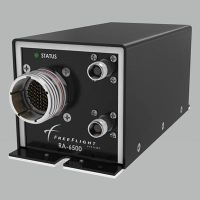
The RA6500 radar altimeter will begin flight testing ahead of schedule. The RA6500, part of the Terrain Series which also features the RA500 and RA7500, each designed for specific segments of aviation, will commence testing in a Cessna 182 aircraft.

The tests will take place over bodies of water, various terrain, near 5G towers known for interference, and will also include steep bank angle testing during the evaluation.

"This is a great advancement for FreeFlight, as the original testing timeline wasn't expected to be met until September at the earliest," mentions Behlul Poonawalla, Director of Engineering. "This is a revolutionary product, and we are eager to see the results from our first flight test."

The new radar altimeter features redesigned RF circuitry built to withstand 5G interference. This adaptation will increase this critical sensor's availability and reliability - the only sensor onboard an aircraft capable of detecting clearance height above terrain - in challenging RF interference environments.

The RA 6500 features comprehensive interface capabilities, including the ARINC 552 legacy interface, which allows integration with legacy analog indicators, greatly simplifying the retrofit of the system. As an additional display option, the
RA 6500 can be paired with the FreeFlight Systems RAD45 standalone indicator, which meets EASA AMC1 SPA.NVIS.110(b) guidelines.

The TSO'd, DAL-B rated RA 6500 meets the FAA's most rigorous design standards, including TSO-C87a Class A, ETSO-2C87, DO-160G, and DO-178C, ensuring commercial transport and military-grade operability.

The RA 6500's small footprint means that it can easily be installed in place of legacy altimeters from multiple manufacturers. The existing antennas can also be used in most installations, making the RA 6500 a very straightforward retrofit solution.

The Terrain Series altimeters feature dual-install capability making them suitable for installation in Part 29 rotorcraft and larger fixed-wing aircraft. The feature-rich radar altimeters have an update rate of 25 times per second (25 Hz), Frequency- Modulated Continuous-Wave (FMCW) at 4.3 GHz center frequency, an altitude range of -20 to 2,500 ft., antenna response angles of up to ±20° pitch and ±30° roll, and a service ceiling of 55,000 ft.

FMI: www.freeflightsystems.com

Advertisement

More News

ANN FAQ: Contributing To Aero-TV

How To Get A Story On Aero-TV News/Feature Programming How do I submit a story idea or lead to Aero-TV? If you would like to submit a story idea or lead, please contact Jim Campbel>[...]

Classic Aero-TV: Bob Hoover At Airventure -- Flight Test and Military Service

From 2011 (YouTube Edition): Aviation's Greatest Living Legend Talks About His Life In Aviation (Part 5, Final) ANN is pleased to offer you yet another snippet from the public conv>[...]

Aero-News: Quote of the Day (11.12.25)

“All Air Traffic Controllers must get back to work, NOW!!! Anyone who doesn’t will be substantially ‘docked. For those Air Traffic Controllers who were GREAT PATR>[...]

ANN's Daily Aero-Linx (11.12.25)

Aero Linx: American Navion Society Welcome to the American Navion Society. Your society is here to support the Navion community. We are your source of technical and operating infor>[...]

ANN's Daily Aero-Term (11.12.25): Glideslope Intercept Altitude

Glideslope Intercept Altitude The published minimum altitude to intercept the glideslope in the intermediate segment of an instrument approach. Government charts use the lightning >[...]

blog comments powered by Disqus


Advertisement

Advertisement

Podcasts

Advertisement

© 2007 - 2025 Web Development & Design by Pauli Systems, LC