Mount Sharp 'Photobombs' Mars Curiosity Rover | Aero-News Network
Aero-News Network
RSS icon RSS feed
podcast icon MP3 podcast
Subscribe Aero-News e-mail Newsletter Subscribe

Airborne Unlimited -- Most Recent Daily Episodes

Episode Date

Airborne-Monday

Airborne-Tuesday

Airborne-Wednesday Airborne-Thursday

Airborne-Friday

Airborne On YouTube

Airborne-Unlimited-09.15.25

AirborneNextGen-
09.09.25

Airborne-Unlimited-09.10.25

Airborne-AffordableFlyers-09.11.25

AirborneUnlimited-09.12.25

Sun, Feb 04, 2018

Mount Sharp 'Photobombs' Mars Curiosity Rover

Agency Releases New Mosaic 'Selfie' Of The Rover

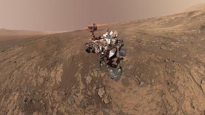
A new self-portrait of NASA's Curiosity Mars rover shows the vehicle on Vera Rubin Ridge, which it has been investigating for the past several months. Directly behind the rover is the start of a clay-rich slope scientists are eager to begin exploring. In coming weeks, Curiosity will begin to climb this slope. In the image, north is on the left and west is on the right, with Gale Crater's rim on the horizon of both edges.

Poking up just behind Curiosity's mast is Mount Sharp, photobombing the robot's selfie. When Curiosity landed on Mars five years ago, the team's intention was to study lower Mount Sharp, where the rover will remain for all of its time on Mars.

The mountain's base provides access to layers formed over millions of years. These layers formed in the presence of water -- likely due to a lake or lakes where sediments accumulated, which formed these layers inside Gale Crater.

The mosaic was assembled from dozens of images taken by Curiosity's Mars Hand Lens Imager (MAHLI). They were all taken on Jan. 23, 2018, during Sol 1943.

(Image provided with NASA news release)

FMI: www.nasa.gov

Advertisement

More News

NTSB Final Report: Evektor-Aerotechnik A S Harmony LSA

Improper Installation Of The Fuel Line That Connected The Fuel Pump To The Four-Way Distributor Analysis: The airplane was on the final leg of a flight to reposition it to its home>[...]

ANN's Daily Aero-Term (09.15.25): Decision Altitude (DA)

Decision Altitude (DA) A specified altitude (mean sea level (MSL)) on an instrument approach procedure (ILS, GLS, vertically guided RNAV) at which the pilot must decide whether to >[...]

Aero-News: Quote of the Day (09.15.25)

“With the arrival of the second B-21 Raider, our flight test campaign gains substantial momentum. We can now expedite critical evaluations of mission systems and weapons capa>[...]

Airborne 09.12.25: Bristell Cert, Jetson ONE Delivery, GAMA Sales Report

Also: Potential Mars Biosignature, Boeing August Deliveries, JetBlue Retires Final E190, Av Safety Awareness Czech plane maker Bristell was awarded its first FAA Type Certification>[...]

Airborne 09.10.25: 1000 Hr B29 Pilot, Airplane Pile-Up, Haitian Restrictions

Also: Commercial A/C Certification, GMR Adds More Bell 429s, Helo Denial, John “Lucky” Luckadoo Flies West CAF’s Col. Mark Novak has accumulated more than 1,000 f>[...]

blog comments powered by Disqus


Advertisement

Advertisement

Podcasts

Advertisement

© 2007 - 2025 Web Development & Design by Pauli Systems, LC