Sun, Apr 21, 2024
UAVOS Debuts UVH 170 Unmanned Wildfire Fighting Helo
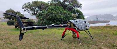
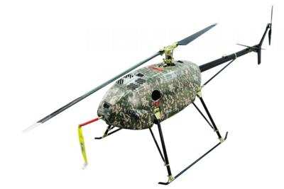
UAVOS has recently achieved a significant milestone in public safety and emergency services with the first operational deployment of its UVH 170 unmanned helicopter, designed specifically for wildfire suppression.
The deployment, which involved both day and night operations, represents a critical advancement in the use of unmanned aerial vehicles (UAVs) in managing natural disasters.
The UVH 170 is equipped with state-of-the-art technology, including the Gimbal 201, which allows for high-precision georeferenced data acquisition through visible-light and thermal imaging cameras. This technology meets the stringent requirements of fire services for target sensitivity, accuracy, and timely data delivery, which are crucial for effective fire management and containment strategies.
During its inaugural field mission, the UAVOS UVH 170 demonstrated its capability to operate autonomously for up to five hours and handle payloads up to 4 kilograms. Such capacity is essential for carrying sophisticated sensors used in both civilian and security applications.
By flying at altitudes of two thousand meters above the ground, the UAV can capture detailed video feeds of the fire's boundaries. These feeds are georeferenced in real-time and streamed back to the UAS ground control station, providing immediate situational awareness to firefighting teams on the ground.
This real-time data transfer is pivotal in eliminating delays often associated with traditional methods of imagery acquisition, interpretation, transmission, and production. Consequently, fire management personnel are equipped with up-to-the-minute updates that enable them to make informed decisions quickly and efficiently. The speed of data processing and delivery enhances the overall responsiveness of firefighting efforts, allowing teams to adapt to changing conditions and effectively allocate resources where they are most needed.
Aliaksei Stratsilatau, CEO of UAVOS, emphasized the operational benefits of the UVH 170, noting that "operating from a safe distance, a drone pilot can identify and geo-locate hot spots providing critical information to the fire management team to aid them with planning, resource management, and assigning tasks and priorities for the day."
The successful deployment of the UVH 170 underscores the growing role of UAV technology in enhancing public safety and emergency response strategies. UAVOS's advancements in UAV technology represent a transformative shift in how emergency services tackle the challenges posed by natural disasters, particularly in the realm of wildfire management.
More News
From 2023 (YouTube Edition): "Ain’t Your Daddy’s Super Cub”—Don Wade Co-owned by Don and Ron Wade—the former of Don’s Dream Machines, a storied >[...]
Pilot-Rated Passenger Reported That The Pilot Did Not Adequately “Round Out” The Landing Flare And The Airplane Bounced And Yawed To The Right Analysis: The pilot state>[...]
Dead Reckoning Dead reckoning, as applied to flying, is the navigation of an airplane solely by means of computations based on airspeed, course, heading, wind direction, and speed,>[...]
Aero Linx: Lake Amphibian Club This website is created and sponsored by the Lake Amphibian Club, to help spread the word about these wonderful, versatile amphibians that can land j>[...]
“I am deeply honored to be sworn in as NASA administrator. NASA’s mission is as imperative and urgent as ever — to push the boundaries of human exploration, ignit>[...]
 Classic Aero-TV: In Praise of Alabamas Patriot Aircraft USA

