SmarTopo Harvest Develops A 'Safe Zone' For UAVS | Aero-News Network
Aero-News Network
RSS icon RSS feed
podcast icon MP3 podcast
Subscribe Aero-News e-mail Newsletter Subscribe

Airborne Unlimited -- Most Recent Daily Episodes

Episode Date

Airborne-Monday

Airborne-Tuesday

Airborne-Wednesday Airborne-Thursday

Airborne-Friday

Airborne On YouTube

Airborne-Unlimited-09.01.25 (Holiday)

Airborne-Unlimited-09.02.25

AirborneUnlimited-08.27.25

Airborne-AffordableFlyers-08.28.25

AirborneUnlimited-08.22.25

Tue, Mar 31, 2015

SmarTopo Harvest Develops A 'Safe Zone' For UAVS

New Obstacle Detection Technology For The SmarTopo Obstacle Management System

Rapid Imaging Software, Inc. introduced SmarTopo Harvest on Monday. This new technology is integrated into the SmarTopo Obstacle Management System. SmarTopo delivers obstacle survey and detection technology plus powerful data management tools for a complete obstacle management system. SmarTopo is certified by the FAA to a level 1B.

Mike Abernathy, Director of Development notes, “SmarTopo Harvest is the key for small commercial drones to operate safely in urban areas. This technology allows companies to create and maintain an obstacle database for their drone operations."

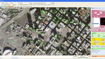
SmarTopo Harvest is the latest obstacle detection technology from Rapid Imaging Software. The software provides a fast and efficient method to detect undocumented obstacles and add new obstacles to a database.

  • Searches for obstacles – the height for the search is set by the analyst
  • Detected objects or structures may be compared to the FAA obstacle database
  • Estimates height of the objects or structures
  • Creates new obstacle for a proprietary database

The issue of undocumented obstacles is extensive. A recent study conducted using SmarTopo Harvest indicates there are a substantial number of undocumented obstacles in the national airspace. An analyst using SmarTopo Harvest identified 52 undocumented obstacles of 200 feet or more in a study area of six square miles around the Los Angeles International Airport.

(Image provided by Rapid Imaging Software)

FMI: www.rapidimaging.net/obstaclemanagement/

Advertisement

More News

YFQ-42A Collaborative Combat Aircraft Starts Flight Testing

Newest USAF Drone Begins Process in Earnest The YFQ-42A Collaborative Combat Aircraft has begun its flight testing in coordination with the U.S. Air Force, taking a vital step towa>[...]

Aero-News: Quote of the Day (09.02.25)

“What a great moment for the U.S. Air Force and for GA-ASI. It’s been our collaboration that enabled us to build and fly the YFQ-42A in just over a year. It’s an >[...]

Delta Settles Fuel Dump Lawsuit in a $78M Handshake

Airline Pilots Jettisoned 15,000 Pounds of Fuel Over Populated Areas Five years after one of its Boeing 777s dumped 15,000 pounds of jet fuel onto neighborhoods, Delta Air Lines ha>[...]

Watchdog Warns of Another Understaffed FAA Program: Meteorology

GAO Report Says that Only 69 Aviation Meteorologists Work Alongside ATC A federal watchdog says the FAA is running the nation’s air traffic system with fewer weather experts >[...]

Airborne 08.27.25: Air Race Tkt Discounts, Europe AvGas, Deportation Flights?

Also: 500-Aircraft Deal With China, Florida ANG's F-35, FAA Denies Petition, UC Central Arkansas Aviation Academy The Reno Air Racing Association (RARA) is offering its apologies t>[...]

blog comments powered by Disqus


Advertisement

Advertisement

Podcasts

Advertisement

© 2007 - 2025 Web Development & Design by Pauli Systems, LC