Airbus Extends Its Reach Into Precision Agriculture Solutions With AgNeo | Aero-News Network
Aero-News Network
RSS icon RSS feed
podcast icon MP3 podcast
Subscribe Aero-News e-mail Newsletter Subscribe

Airborne Unlimited -- Most Recent Daily Episodes

Episode Date

Airborne-Monday

Airborne-Tuesday

Airborne-Wednesday Airborne-Thursday

Airborne-Friday

Airborne On YouTube

Airborne-Unlimited-05.05.25

Airborne-NextGen-05.06.25

AirborneUnlimited-05.07.25

Airborne-Unlimited-05.01.25

AirborneUnlimited-05.02.25

Mon, Mar 16, 2020

Airbus Extends Its Reach Into Precision Agriculture Solutions With AgNeo

A New Precision Farming Solution For Commodity And Permanent Crops

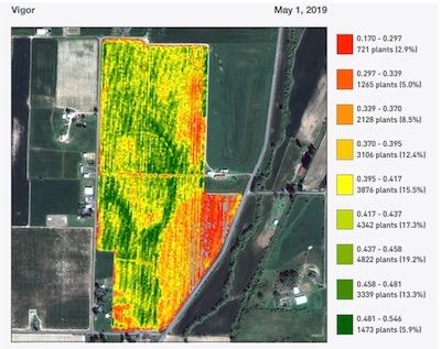
Airbus has launched AgNeo, its new integrated precision farming solution for commodity and permanent crops. Delivering in-season actionable information based on satellite imagery and premium agronomic analytics, AgNeo will help customers save time, optimise inputs and increase yields.

AgNeo leverages Airbus’ 30-year experience in the agriculture market and the long-standing and fruitful collaboration with its customers to propose a wide range of crop analytics. Based on imagery-derived health maps from SPOT, Pléiades, Sentinel-2 and Landsat 8 data, they support a wide range of capabilities: from alerting features that direct agronomists to scout areas in their fields that require immediate attention, to the creation of management zones and variable rate application maps. Thanks to an Airbus-proprietary processing chain that normalizes data across all sensors, AgNeo customers can also derive absolute agronomic indicators to use as input to their own models for building nitrogen recommendation or establishing water budgets.

AgNeo also provides enhanced analytics for high value permanent crops such as almonds, apples and grapes. Using 20-inch resolution data from Pléiades, AgNeo creates a mask of all the tree crowns to remove noise from background vegetation and soil, improving the results and bringing analytics to the tree level. These analytics include a stand count inventory eliminating time-consuming and error-prone manual tree counts. The product will be able to utilize 12-inch data from Airbus’ new Pléiades Neo satellites due to be launched later this year.

The AgNeo solution is available with a full user interface and will also be accessible via APIs.

(Image provided with Airbus news release)

FMI: www.airbus.com

Advertisement

More News

ANN's Daily Aero-Linx (05.06.25)

Aero Linx: International Federation of Airworthiness (IFA) We aim to be the most internationally respected independent authority on the subject of Airworthiness. IFA uniquely combi>[...]

ANN's Daily Aero-Term (05.06.25): Ultrahigh Frequency (UHF)

Ultrahigh Frequency (UHF) The frequency band between 300 and 3,000 MHz. The bank of radio frequencies used for military air/ground voice communications. In some instances this may >[...]

ANN FAQ: Q&A 101

A Few Questions AND Answers To Help You Get MORE Out of ANN! 1) I forgot my password. How do I find it? 1) Easy... click here and give us your e-mail address--we'll send it to you >[...]

Classic Aero-TV: Virtual Reality Painting--PPG Leverages Technology for Training

From 2019 (YouTube Edition): Learning To Paint Without Getting Any On Your Hands PPG's Aerospace Coatings Academy is a tool designed to teach everything one needs to know about all>[...]

Airborne 05.02.25: Joby Crewed Milestone, Diamond Club, Canadian Pilot Insurance

Also: Sustainable Aircraft Test Put Aside, More Falcon 9 Ops, Wyoming ANG Rescue, Oreo Cookie Into Orbit Joby Aviation has reason to celebrate, recently completing its first full t>[...]

blog comments powered by Disqus


Advertisement

Advertisement

Podcasts

Advertisement

© 2007 - 2025 Web Development & Design by Pauli Systems, LC