UAV Test Site Adds Airport Runway As Option For Test Flights | Aero-News Network
Aero-News Network
RSS icon RSS feed
podcast icon MP3 podcast
Subscribe Aero-News e-mail Newsletter Subscribe

Airborne Unlimited -- Most Recent Daily Episodes

Episode Date

Airborne-Monday

Airborne-Tuesday

Airborne-Wednesday Airborne-Thursday

Airborne-Friday

Airborne On YouTube

Airborne-Unlimited-04.29.24

Airborne-Unlimited-04.23.24

Airborne-Unlimited-04.24.24 Airborne-FltTraining-04.25.24

Airborne-Unlimited-04.26.24

Fri, Sep 12, 2014

UAV Test Site Adds Airport Runway As Option For Test Flights

FAA-Approved Range For Lone Star Unmanned Aircraft Systems Center Includes Port Mansfield Airport

The Lone Star Unmanned Aircraft Systems Center at Texas A&M University-Corpus Christi now has an airport and runway in its approved flight ranges.

The FAA recently approved a new range to test and fly unmanned aircraft that includes the Port Mansfield airport.

The center, located in Corpus Christi, is one of only six federally-designated test sites for unmanned aircraft systems (UAS). The sites will provide critical data to the FAA, as the agency develops rules, processes and procedures required to safely operate UAS, commonly called drones, in the national airspace.

“With this approved range, which has a runway, we are expanding our operations and capacities for UAS testing for operation and development,” said Dr. Luis Cifuentes, Director of the Lone Star UAS Center and the University’s Vice President for Research, Commercialization and Outreach. “Now aircraft with landing gear that need a landing strip can test and fly with our center.”

The Center plans to build a hangar and pave a path to the runway, improvements planned in partnership with the Willacy County Navigation District.

The first flights at the Port Mansfield range are expected by the end of October.

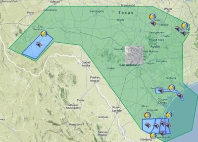
The Port Mansfield range, which is a 45-minute drive from Harlingen, Texas, is adjacent to another approved range south of Corpus Christi near Sarita, Texas, where the University regularly flies its 13-foot-wingspan unmanned aircraft vehicle (UAV). At that range, the UAV belly lands in the soft, sandy flats common in that area as the craft does not need a runway.

The Lone Star UAS Center has proposed additional ranges west of Port Mansfield. See a map of the test ranges at lsuasc.tamucc.edu.

“The Lone Star UAS Center provides testing capabilities 290 flying days a year over mountains, high deserts, agriculture, coastal and maritime topographies, along the Gulf of Mexico and over virtually unpopulated regions. It’s the ideal research environment for testing.” Cifuentes said.

Since the test site designation in December, the Lone Star Center has received inquiries from more than 60 private companies and other organizations that want to test and research aircraft, software or other possible uses for unmanned aircraft, commonly referred to as drones.

The use of unmanned aircraft is vital to research, business and safety. Areas of use for UAS are likely to include Search-and-Rescue missions, surveying disaster areas or accident scenes; mapping coastlines to observe changes over time; and inventory of wildlife, habitats, agriculture and pipelines through remote areas.

While the test site designation does not come with federal funding, studies show an anticipated economic impact, once airspace is opened to UAS, would be about $6.5 billion and 8,256 jobs statewide from 2015 to 2025.

FMI: http://lsuasc.tamucc.edu/

Advertisement

More News

Unfortunate... ANN/SportPlane Resource Guide Adds To Cautionary Advisories

The Industry Continues to be Rocked By Some Questionable Operations Recent investigations and a great deal of data has resulted in ANN’s SportPlane Resource Guide’s rep>[...]

ANN FAQ: Turn On Post Notifications

Make Sure You NEVER Miss A New Story From Aero-News Network Do you ever feel like you never see posts from a certain person or page on Facebook or Instagram? Here’s how you c>[...]

ANN's Daily Aero-Term (04.29.24): Visual Approach Slope Indicator (VASI)

Visual Approach Slope Indicator (VASI) An airport lighting facility providing vertical visual approach slope guidance to aircraft during approach to landing by radiating a directio>[...]

ANN's Daily Aero-Term (04.28.24): Airport Marking Aids

Airport Marking Aids Markings used on runway and taxiway surfaces to identify a specific runway, a runway threshold, a centerline, a hold line, etc. A runway should be marked in ac>[...]

ANN's Daily Aero-Linx (04.28.24)

Aero Linx: The Skyhawk Association The Skyhawk Association is a non-profit organization founded by former Skyhawk Pilots which is open to anyone with an affinity for the A-4 Skyhaw>[...]

blog comments powered by Disqus


Advertisement

Advertisement

Podcasts

Advertisement

© 2007 - 2024 Web Development & Design by Pauli Systems, LC