FAA Expands B4UFLY Drone Programs | Aero-News Network
Aero-News Network
RSS icon RSS feed
podcast icon MP3 podcast
Subscribe Aero-News e-mail Newsletter Subscribe

Airborne Unlimited -- Most Recent Daily Episodes

Episode Date

Airborne-Monday

Airborne-Tuesday

Airborne-Wednesday Airborne-Thursday

Airborne-Friday

Airborne On YouTube

Airborne-Unlimited-04.28.25

Airborne-NextGen-04.29.25

AirborneUnlimited-04.30.25

Airborne-Unlimited-05.01.25

AirborneUnlimited-05.02.25

Fri, Feb 02, 2024

FAA Expands B4UFLY Drone Programs

B4UFLY Service Shows Recreational Drone Flyers Where They Can And Cannot Fly

The FAA is now partnering with several companies to offer drone pilots more places to receive official airspace awareness information. 

The FAA’s B4UFLY service shows recreational drone flyers where they can and cannot fly.  

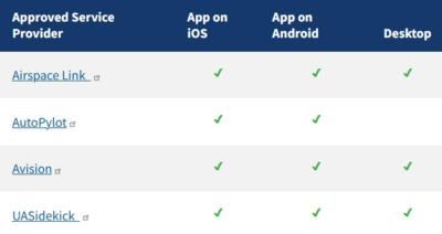
The FAA has approved four companies to provide B4UFLY services through desktop and mobile applications. Approved companies will offer multiple ways to access B4UFLY and bring recreational flyers the latest airspace awareness information directly from the agency.  

The rule for operating unmanned aircraft systems (UAS) or drones under 55 pounds in the National Airspace System (NAS) is 14 CFR Part 107, referred to as the Small UAS Rule. 

However, if you want to fly a drone for purely recreational purposes, there is a limited statutory exception ("carve out") that provides a basic set of requirements.

The companies noted in the attached table also are also FAA-approved UAS Service Suppliers of the Low Altitude Authorization and Notification Capability.  

Key features of B4UFLY include:

  • Information about controlled airspace, special use airspace, critical infrastructure, airports, national parks and military training routes
  • Information about Temporary Flight Restrictions for special events.
  • A clear status indicator that informs the operator whether it is safe to fly or not. 
    • For example, an indicator shows that flying in the Special Flight Rules Area around Washington, D.C. is prohibited.
  • Informative, interactive maps with filtering options.
  • The ability to check whether it is safe to fly in different locations by searching for a location or moving the location pin.
  • Links to other FAA drone resources.
FMI: www.faa.gov/uas/getting_started/laanc#approved

Advertisement

More News

NTSB Final Report: Cozy Cub

Witness Reported The Airplane Was Flying Low And Was In A Left Bank When It Struck The Power Line Analysis: The pilot was on final approach to land when the airplane collided with >[...]

ANN FAQ: Contributing To Aero-TV

How To Get A Story On Aero-TV News/Feature Programming How do I submit a story idea or lead to Aero-TV? If you would like to submit a story idea or lead, please contact Jim Campbel>[...]

Classic Aero-TV: Seated On The Edge Of Forever -- A PPC's Bird's Eye View

From 2012 (YouTube Edition): A Segment Of The Sport Aviation World That Truly Lives "Low And Slow" Pity the life of ANN's Chief videographer, Nathan Cremisino... shoot the most exc>[...]

ANN's Daily Aero-Linx (04.29.25)

Aero Linx: International Business Aviation Council (IBAC) IBAC promotes the growth of business aviation, benefiting all sectors of its industry and in all regions of the world. As >[...]

ANN's Daily Aero-Term (04.29.25): Execute Missed Approach

Execute Missed Approach Instructions issued to a pilot making an instrument approach which means continue inbound to the missed approach point and execute the missed approach proce>[...]

blog comments powered by Disqus


Advertisement

Advertisement

Podcasts

Advertisement

© 2007 - 2025 Web Development & Design by Pauli Systems, LC