Airbus Defense And Space Completes Second Copernicus 'Eye' | Aero-News Network
Aero-News Network
RSS icon RSS feed
podcast icon MP3 podcast
Subscribe Aero-News e-mail Newsletter Subscribe

Airborne Unlimited -- Most Recent Daily Episodes

Episode Date

Airborne-Monday

Airborne-Tuesday

Airborne-Wednesday Airborne-Thursday

Airborne-Friday

Airborne On YouTube

Airborne-Unlimited-05.19.25

Airborne-NextGen-05.20.25

AirborneUnlimited-05.21.25

Airborne-AffordableFlyers-05.22.25

AirborneUnlimited-05.23.25

Mon, Jun 20, 2016

Airbus Defense And Space Completes Second Copernicus 'Eye'

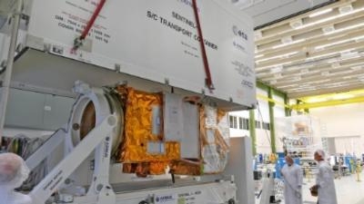
Sentinel-2B Optical Satellite Ready For Environmental Testing At ESTEC

The Sentinel-2B optical satellite is the second of its type from Airbus Defence and Space, providing the "Color Vision" of Europe´s Earth observation program Copernicus, a joint project of the European Commission and the European Space Agency (ESA). In the coming months, the completed satellite will undergo a series of environmental tests at ESA’s research and technology center ESTEC, Noordwijk (The Netherlands), to determine its readiness for flight.

The Sentinel-2 mission, designed and built by a consortium of around 60 companies led by Airbus Defence and Space, is based on a constellation of two identical satellites flying in the same orbit, 180° apart for optimal coverage and data delivery. Together they image all Earth’s land surfaces, large islands, inland and coastal waters every five days at the equator. Sentinel-2A was launched on 23 June 2015, its twin, Sentinel-2B, will follow early next year.

The Sentinel-2 satellites deliver optical images from the visible-near infrared to short-wave infrared range of the electromagnetic spectrum using a total of 13 spectral bands with a spatial resolution of 10, 20 or 60 meters and a swath width of 290 km. Sentinel-2 is dedicated to monitor land use and management, soil sealing, forest and crops. It may also be used to observe natural disasters like floods, forest fires, landslides, and coastal erosion to support ground humanitarian aid.

The Sentinel-1 and -2 satellites are equipped with the Tesat-Spacecom’s laser communication terminal. The SpaceDataHighway is being implemented within a Public-Private Partnership between ESA and Airbus Defense and Space.

(Image provided with Airbus Defense and Space news release)

FMI: www.airbus.com

Advertisement

More News

ANN's Daily Aero-Term (05.29.25): Terminal Radar Service Area

Terminal Radar Service Area Airspace surrounding designated airports wherein ATC provides radar vectoring, sequencing, and separation on a full-time basis for all IFR and participa>[...]

ANN's Daily Aero-Term (05.30.25): Very High Frequency (VHF)

Very High Frequency (VHF) The frequency band between 30 and 300 MHz. Portions of this band, 108 to 118 MHz, are used for certain NAVAIDs; 118 to 136 MHz are used for civil air/grou>[...]

Aero-News: Quote of the Day (05.30.25)

“From approximately November 2021 through January 2022, Britton-Harr, acting on behalf of AeroVanti, entered into lease-purchase agreements for five Piaggio-manufactured airc>[...]

Airborne 05.23.25: Global 8000, Qatar B747 Accepted, Aviation Merit Badge

Also: Virtual FLRAA Prototype, IFR-Capable Autonomous A/C, NS-32 Crew, Golden Dome Missile Defense Bombardier announced that the first production Global 8000 successfully completed>[...]

ANN's Daily Aero-Linx (05.30.25)

Aero Linx: The 1-26 Association (Schweizer) The Association’s goal is to foster the helpfulness, the camaraderie, and the opportunity for head-to-head competition that is fou>[...]

blog comments powered by Disqus


Advertisement

Advertisement

Podcasts

Advertisement

© 2007 - 2025 Web Development & Design by Pauli Systems, LC