Big-Screen Portable Aviation Navigator Adds Airways, Expanded
WX
Garmin got a leap on new product announcements ahead of next
week's AOPA Expo in San Jose, CA... with the introduction of a
significant leap forward for portable navigation devices. The
electronics and avionics maker announced its flagship GPSMAP 696
Thursday morning, a tablet-style device that builds on the already
impressive capabilities of its smaller GPSMAP 496.
The new 696 incorporates the popular aviation features of the
GPSMAP 496 while also adding new capabilities such as airways,
electronic charts and expanded weather. In addition, the GPSMAP
696's information is displayed on a screen that is three times
larger than the GPSMAP 496.
"The GPSMAP 696 gives pilots exactly what they have been looking
for, a GPS with a large screen, electronic charts and real-time
weather," said Gary Kelley, Garmin's vice president of marketing.
"It's our most feature rich, easy-to-use aviation portable, and is
ideal for those wanting to minimize flipping through paper charts
while in the cockpit."

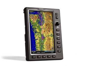
The GPSMAP 696 sports a large, 7-inch portrait screen that makes
it possible to view an entire approach plate on the display. The
high-resolution, sunlight readable screen uses Garmin's latest
technology to ensure that pilots will be able to read the vibrant
display day or night.
The bezel that frames the bright screen has multiple keys on the
bottom and right sides. The soft keys at the bottom of the display
control the most commonly used features of the current page, such
as turning the weather display on/off.

The dedicated keys on the display's right side have specific
functions such as nearest, direct to, flight plan, zoom in/out and
menu. Also on the display's right side is a rotary knob/joystick
--similar to the G1000's joystick -- that lets pilots enter airport
identifiers, pan the map, or scroll to page and sub-page
groups.
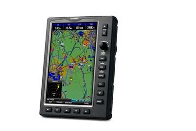
Part 91 pilots may be tempted to leave their IFR enroute paper
charts at home, thanks to the 696's new IFR map mode. This mode
displays a map similar to a standard enroute chart that has
important features like victor airways, jet routes, minimum enroute
altitude (MEA) and leg distance. Garmin argues the 696's IFR map
mode offers better situational awareness than traditional charts,
because it also subtlety displays major visual reference points
like rivers, state boundaries, highways and railroad tracks from
Garmin's built-in basemap.
The GPSMAP 696 also includes Garmin FliteCharts, an electronic
version of the National Aeronautical Chart Office (NACO) US
Terminal Procedures Publication. With FliteCharts, pilots can
quickly find and view all NACO departure procedures (DP), standard
terminal arrival routes (STARs), approach charts and airport
diagrams. If the current approach is known, the GPSMAP 696
automatically selects the correct chart based on the flight
plan.

FliteCharts are available every 28 days, and will not be
available on the 696 if they are not updated regularly. The GPSMAP
696 may be used in lieu of paper approach charts when used in
accordance with AC 90-78.
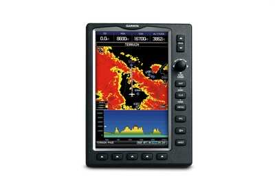
Like the previous 396 and 496 handhelds, the GPSMAP 696 has a
receiver for XM radio and XM WX Satellite Weather (US customers
only) that gives next-generation radar (NEXRAD), aviation routine
weather reports (METARs), terminal aerodrome forecasts (TAFs),
temporary flight restrictions (TFRs), lightning, winds aloft,
turbulence forecasts, and several other important weather products.
The 696 builds on those offerings as Garmin's first portable device
with PIREPs and icing forecast information.
The weather data may be laid directly over the unit's navigation
and topographic map databases. Weather and radio information is
delivered to the 696 via Garmin's new GXM 40 smart antenna, which
is included with the GPSMAP 696. XM WX subscription data is
available from XM WX Satellite Weather.

Other popular features found on the GPSMAP 696 include Smart
Airspace, SafeTaxi and AOPA Airport Directory data. Suggested
pricing for the GPSMAP 696 is $3,295, including a yoke mount, GXM
40 antenna, cigarette lighter adapter and AC adapter cable,
USB-to-PC interface cable, low-profile remote GPS antenna, unit
cover, free Jeppesen update certificate, owner's manual and
quick-reference guide.
North American customers who don't need XM radio and XM WX
Satellite Weather may opt instead the GPSMAP 695 Americas, that has
identical features to the GPSMAP 696 except that it does not
include the GXM 40 smart antenna and may not be upgraded to add XM
datalink capability in the future. Pricing for the 695 begins at
$2,695.
Garmin also offers a GPSMAP 695 Atlantic and GPSMAP 695 Pacific
version for customers in Europe and Australasia, respectively. The
GPSMAP 695 Atlantic is pre-loaded with VFR reporting points (VRPs),
private airports, and obstacles. The GPSMAP 695 Atlantic and
Pacific do not include XM capability, AOPA Airport Directory,
FliteCharts or SafeTaxi diagrams.
 NTSB Final Report: Cozy Cub