PrecisionHawk, Verizon, Harris And DigitalGlobe Working Through FAA Pathfinder And NASA UTM Frameworks
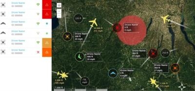
A group of four companies says they have successfully completed initial testing of high-performance airspace services for consumer and enterprise drones. The companies have integrated their technologies ... Verizon's LTE network, Harris' ADS-B and aircraft surveillance network, DigitalGlobe's Geospatial Big Data Platform and PrecisionHawk's LATAS (Low Altitude Traffic and Airspace Safety) platform ... to serve as a pathway for safe drone integration. Assessment of this ecosystem is currently taking place through the FAA Pathfinder program and the NASA UTM project.
"With this collaboration, the innovation of the tech community is addressing the timely need for a safety services to accelerate drone integration," said Tyler Collins, Director of LATAS at PrecisionHawk. "Verizon, Harris and DigitalGlobe bring technology components, expertise and credibility that are critical to the success of this ecosystem. We look forward to expanding testing through the FAA Pathfinder and NASA UTM programs in 2015."
"LTE networks have the potential to allow drones to deliver sensor data for processing, analysis and decision-making mid-flight and to receive command-and-control inputs in real-time, resulting in a safer, more reliable shared airspace," said David Famolari, Director, Verizon Ventures. "While much further study is required, this demonstration is an important step in advancing industry efforts to safely manage commercial UAV operations at scale."
Operating over LTE and through satellites, the LATAS platform connects airspace safety technologies such as detect and avoid, dynamic geofencing and aircraft tracking to provide "safety as a service" for the rapidly growing drone market. As the most reliable cellular network provider in the United States with the most 4G LTE coverage, Verizon brings secure and reliable connectivity to LATAS users. By utilizing the existing infrastructure of Verizon cell towers, LATAS is scalable for drones operating throughout the US.
"We are leveraging satellite-derived information to create consistent information and analytics for safe drone flights," said Dr. Shay Har-Noy, DigitalGlobe's Senior Director of Geospatial Big Data. "This is significant collaboration that represents a huge step forward for the FAA and the safety and well-being of the American public."
As a leading global provider of commercial high-resolution earth observation and advanced geospatial solutions, DigitalGlobe brings superior geospatial content and analytic capabilities for the identification of terrain and ground obstacles. PrecisionHawk's LATAS system will tap into DigitalGlobe's Geospatial Big Data (GBD) Platform so that drones can actively identify and avoid obstructions such as buildings, cable or tree lines based on highly accurate and current information about the world around them.

Nationwide Automatic Dependent Surveillance-Broadcast (ADS-B) ground station deployment by Harris serves as the cornerstone of the FAA's NextGen surveillance initiative to fundamentally improve the quality, accuracy and reliability of flight tracking data throughout the entire National Airspace System (NAS).
The Harris data is a synthesis of all FAA system derived aircraft surveillance data available in the U.S. National Airspace System. The sources of Harris data consist of data derived directly from the U.S. national ADS-B network being deployed by Harris; ADS-B data; FAA en-route and terminal primary and secondary surveillance data; airport surface surveillance data from the FAA Airport Surface Detection Equipment-X Band (ASDE-X); Wide Area Multilateration (WAM) from FAA deployed WAM systems and flight plan data from the FAA host system. An integrated system between PrecisionHawk, Verizon, Digital Globe, and Harris can provide a more complete solution for UAS traffic management.
By bringing together the industry's most advanced technologies and smartest minds, PrecisionHawk is working with the FAA and government officials to present and test the LATAS platform as a safe, reliable and scalable service for drones. PrecisionHawk will continue to bring in key technology and testing partners as the ecosystem expands its capabilities.
(Source: PrecisionHawk news release. Images from PrecisionHawk YouTube video)
 Airborne 07.02.25: TikToker Arrested, Vietnam A/L Ground Hit, ATC Modernization
 Airborne Affordable Flyers 07.03.25: Sonex HW, BlackShape Gabriel, PRA Fly-In 25
 ANN's Daily Aero-Term (07.07.25): Discrete Code
 Classic Aero-TV: DeltaHawk Aero Engine Defies Convention
 ANN's Daily Aero-Linx (07.07.25)


