Drone Impacts Seattle's Space Needle On New Year's Eve | Aero-News Network
Aero-News Network
RSS icon RSS feed
podcast icon MP3 podcast
Subscribe Aero-News e-mail Newsletter Subscribe

Airborne Unlimited -- Most Recent Daily Episodes

Episode Date

Airborne-Monday

Airborne-Tuesday

Airborne-Wednesday Airborne-Thursday

Airborne-Friday

Airborne On YouTube

Airborne-Unlimited-10.06.25

AirborneNextGen-
10.07.25

Airborne-Unlimited-10.08.25

Airborne-FlightTraining-10.09.25

AirborneUnlimited-10.10.25

Sat, Jan 14, 2017

Drone Impacts Seattle's Space Needle On New Year's Eve

Video Footage Of The Accident And Aircraft Handed Over To Local Police

A drone taking video of Seattle's Space Needle on New Year's Eve suddenly darted towards the structure and impacted the topmost viewing platform where workers were preparing the city's New Year's Eve fireworks.

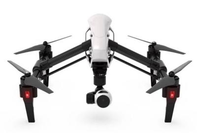
Space Needle representative Dave Mandapat provided a copy of the video of the incident to Ars Technica, as well as to the Seattle Police Department. The aircraft was reportedly a DJI Inspire 1. The video shows some spectacular views of the Space Needle and surrounding area before it races towards the platform and strikes a spotlight. It is recovered by workers preparing the fireworks show while the video continues to roll.

Mandapat said that the video was not handed over to police immediately because of the time constraint of getting the show ready to go, and then time off for the New Year's Day holiday, according to the report. The FAA was contacted January 9, and the agency told Space Needle employees to file a police report on January 10. The Seattle Police confirm that the drone has been "placed in evidence" with the department.

Seattle police spokesman Detective Mark Jamieson told Ars Technica that it has not yet been determined whether there will be any charges filed in the case.

Worth noting is that the video appears to have been edited, with no shots of the point of origin of the flight, and some "fade-to-black" transitions. However, the camera could have been activated after the drone took off, and the DJI website indicates that the app for the aircraft contains multiple camera controls, so such fades might be possible as camera shots change in flight.

Mandapat said the drone might have launched from one of the hotels near the Space Needle, and it had to be "700 or 800 feet off the ground" to get some of the shots on the video.

It was not reported if the drone had a registration number, or to whom it might have been registered.

(Image from file. Video link below)

FMI: Video

Advertisement

More News

True Blue Power and Mid-Continent Instruments and Avionics Power NBAA25 Coverage

Mid-Continent Instruments and Avionics and True Blue Power ANN's NBAA 2025 Coverage... Visit Them At Booth #3436 101 Aviation Nears STC Approval for Lithium Battery Upgrade on Gulf>[...]

ANN's Daily Aero-Term (10.11.25): Hertz

Hertz The standard radio equivalent of frequency in cycles per second of an electromagnetic wave. Kilohertz (kHz) is a frequency of one thousand cycles per second. Megahertz (MHz) >[...]

Aero-News: Quote of the Day (10.11.25)

“NATCA does not endorse, support, or condone any federal employees participating in or endorsing a coordinated activity that negatively affects the capacity of the NAS, or an>[...]

ANN's Daily Aero-Linx (10.11.25)

Aero Linx: European Association for Aviation Psychology (EAAP) Since 1956 the European Association for Aviation Psychology (EAAP) provides a forum for professionals working in the >[...]

NTSB Prelim: Pegasus Quantum 15

Aircraft Experienced A Total Loss Of Engine Power During A Go-Around Attempt And Then Impacted A Soybean Field On September 13, 2025, at 1625 eastern daylight time, a Pegasus Quant>[...]

blog comments powered by Disqus


Advertisement

Advertisement

Podcasts

Advertisement

© 2007 - 2025 Web Development & Design by Pauli Systems, LC