FAA Improves Alaskan Charts | Aero-News Network
Aero-News Network
RSS icon RSS feed
podcast icon MP3 podcast
Subscribe Aero-News e-mail Newsletter Subscribe

Airborne Unlimited -- Most Recent Daily Episodes

Episode Date

Airborne-Monday

Airborne-Tuesday

Airborne-Wednesday Airborne-Thursday

Airborne-Friday

Airborne On YouTube

Airborne-Unlimited-06.23.25

Airborne-NextGen-06.24.25

AirborneUnlimited-06.25.25

Airborne-AffordableFlyers-06.26.25

AirborneUnlimited-06.27.25

Sat, Mar 26, 2022

FAA Improves Alaskan Charts

New Updates Display Mountain Passes So Everyone can Fly Like a Local

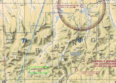
The FAA has added 2 mountain passes to the VFR charts in Northern Alaska, improving operational safety in the region amid a concerted agency effort to improve Alaskan aviation conditions. 

The new terrain identifies the Naqsralugiaq and Carter passes after consultation with local aviators, FAA personnel, and stakeholders in the area. The agency says that more than 60 mountain passes are charted, hopefully enhancing the situational awareness of pilots operating under visual flight rules, and offering them another, safer route. The Naqsralugiaq pass at 3,589 feet for example, lies to the East of Atigun Pass at 4,834 feet. With only a few miles, pilots can avail themselves of almost 1,250 feet of additional altitude they may not have otherwise known about. 

More charting improvements are inbound, say those within the project. The study completed last year to examine Alaska's biggest safety challenges has really borne fruit in 2022. Recently, the FAA sprung for 8 new AWOS stations in the region, further honing the most cost-effective, safety-enhancing tool at an aviator's disposal: Situational awareness. It's another example of a "back to basics" approach to safety - no tricks, no fancy new whiz-bang equipment trying to make a name for itself, just old-fashioned, intelligent airmanship. 

“For years, the safest routes through passes were known primarily to local pilots,” said FAA Administrator Steve Dickson. “Now, all pilots will have the critical terrain information they need to fly safely.”

The region is commonly cloudy and icy, forcing VFR aircraft down to lower altitudes. Mountain passes, when used correctly, can be a great help to aviators making the most of the performance at their disposal. Sadly, the exact passes can remain a locals-only affair, part of a verbal tradition that until now could only be extrapolated from elevation data. With the charting changes, pilots will be able to plan and fly more like a local, improving their safety margin. General aviation is the lifeblood of the state's economy, and every bit of know-how helps the mission for the fully loaded, underpowered aircraft waddling their way through the bush. 

FMI: www.faa.gov

Advertisement

More News

NTSB Prelim: Piper PA-23

Pilot Also Reported That Due To A Fuel Leak, The Auxiliary Fuel Tanks Were Not Used On June 4, 2025, at 13:41 eastern daylight time, a Piper PA-23, N2109P, was substantially damage>[...]

ANN FAQ: Submit a News Story!

Have A Story That NEEDS To Be Featured On Aero-News? Here’s How To Submit A Story To Our Team Some of the greatest new stories ANN has ever covered have been submitted by our>[...]

Classic Aero-TV: One Man’s Vietnam

From 2023 (YouTube Edition): Reflections on War’s Collective Lessons and Cyclical Nature The exigencies of war ought be colorblind. Inane social-constructs the likes of racis>[...]

ANN's Daily Aero-Linx (07.03.25)

Aero Linx: Colorado Pilots Association (CPA) Colorado Pilots Association was incorporated as a Colorado Nonprofit Corporation in 1972. It is a statewide organization with over 700 >[...]

ANN's Daily Aero-Term (07.03.25): High Speed Taxiway

High Speed Taxiway A long radius taxiway designed and provided with lighting or marking to define the path of aircraft, traveling at high speed (up to 60 knots), from the runway ce>[...]

blog comments powered by Disqus


Advertisement

Advertisement

Podcasts

Advertisement

© 2007 - 2025 Web Development & Design by Pauli Systems, LC