FAA Expands B4UFLY Drone Programs | Aero-News Network
Aero-News Network
RSS icon RSS feed
podcast icon MP3 podcast
Subscribe Aero-News e-mail Newsletter Subscribe

Airborne Unlimited -- Most Recent Daily Episodes

Episode Date

Airborne-Monday

Airborne-Tuesday

Airborne-Wednesday Airborne-Thursday

Airborne-Friday

Airborne On YouTube

Airborne-Unlimited-07.07.25

Airborne-NextGen-07.08.25

AirborneUnlimited-07.09.25

Airborne-AffordableFlyers-06.26.25

AirborneUnlimited-06.27.25

Fri, Feb 02, 2024

FAA Expands B4UFLY Drone Programs

B4UFLY Service Shows Recreational Drone Flyers Where They Can And Cannot Fly

The FAA is now partnering with several companies to offer drone pilots more places to receive official airspace awareness information. 

The FAA’s B4UFLY service shows recreational drone flyers where they can and cannot fly.  

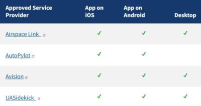
The FAA has approved four companies to provide B4UFLY services through desktop and mobile applications. Approved companies will offer multiple ways to access B4UFLY and bring recreational flyers the latest airspace awareness information directly from the agency.  

The rule for operating unmanned aircraft systems (UAS) or drones under 55 pounds in the National Airspace System (NAS) is 14 CFR Part 107, referred to as the Small UAS Rule. 

However, if you want to fly a drone for purely recreational purposes, there is a limited statutory exception ("carve out") that provides a basic set of requirements.

The companies noted in the attached table also are also FAA-approved UAS Service Suppliers of the Low Altitude Authorization and Notification Capability.  

Key features of B4UFLY include:

  • Information about controlled airspace, special use airspace, critical infrastructure, airports, national parks and military training routes
  • Information about Temporary Flight Restrictions for special events.
  • A clear status indicator that informs the operator whether it is safe to fly or not. 
    • For example, an indicator shows that flying in the Special Flight Rules Area around Washington, D.C. is prohibited.
  • Informative, interactive maps with filtering options.
  • The ability to check whether it is safe to fly in different locations by searching for a location or moving the location pin.
  • Links to other FAA drone resources.
FMI: www.faa.gov/uas/getting_started/laanc#approved

Advertisement

More News

Airborne 07.02.25: TikToker Arrested, Vietnam A/L Ground Hit, ATC Modernization

Also: Outlaw Prop 4 Mooney, Ready 4 Duty, Ukrainian F-16 Pilot Lost, Blue Origin Flt On his journey to become the first pilot to land solo on all seven continents, 19-year-old Etha>[...]

Airborne Affordable Flyers 07.03.25: Sonex HW, BlackShape Gabriel, PRA Fly-In 25

Also: DarkAero Update, Electric Aircraft Symposium, Updated Instructor Guide, OSH Homebuilts Celebrate The long-awaited Sonex High Wing prototype has flown... the Sonex gang tells >[...]

ANN's Daily Aero-Term (07.07.25): Discrete Code

Discrete Code As used in the Air Traffic Control Radar Beacon System (ATCRBS), any one of the 4096 selectable Mode 3/A aircraft transponder codes except those ending in zero zero; >[...]

Classic Aero-TV: DeltaHawk Aero Engine Defies Convention

From 2023 (YouTube Edition): Deviation from the Historical Mean Racine, Wisconsin-based DeltaHawk is a privately-held manufacturer of reciprocating engines for aircraft and hybrid >[...]

ANN's Daily Aero-Linx (07.07.25)

Aero Linx: Formation and Safety Team (F.A.S.T.), USA The Formation and Safety Team (FAST) is a worldwide, educational organization dedicated to teaching safe formation flying in Wa>[...]

blog comments powered by Disqus


Advertisement

Advertisement

Podcasts

Advertisement

© 2007 - 2025 Web Development & Design by Pauli Systems, LC