Thu, Jul 21, 2005
Rockwell Collins Completes Successful SE-Vision Test
Flights
 Rockwell Collins' SE-Vision program
has reached a new milestone by successfully completing military and
commercial test flights in New Mexico and New Jersey in June.
SE-Vision flight deck technology, which integrates synthetic vision
generated scenes with real-time enhanced vision imagery, is being
developed by Rockwell Collins in collaboration with the Federal
Aviation Administration (FAA), the Air Force Research Lab (AFRL),
NASA Langley Research Center and Max-Viz.
Rockwell Collins' SE-Vision program
has reached a new milestone by successfully completing military and
commercial test flights in New Mexico and New Jersey in June.
SE-Vision flight deck technology, which integrates synthetic vision
generated scenes with real-time enhanced vision imagery, is being
developed by Rockwell Collins in collaboration with the Federal
Aviation Administration (FAA), the Air Force Research Lab (AFRL),
NASA Langley Research Center and Max-Viz.
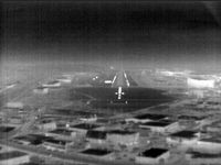 The SE-Vision program flight tests
demonstrated concepts for sensor and synthetic imagery for use by
the US Air Force's mobility operations in a low altitude tactical
environment. The flights were conducted through June on the FAA
William J. Hughes Technical Center's Boeing 727-100 which was
equipped with Rockwell Collins HGS-4000 Heads-Up Guidance System
(HGSTM), Max-Viz Dual Band Infrared Sensors, Rockwell Collins
MultiScan Hazard Weather Detection System and an LCD head-down
display (HDD). SE-Vision display and guidance concepts were shown
on both the HUD and the HDD.
The SE-Vision program flight tests
demonstrated concepts for sensor and synthetic imagery for use by
the US Air Force's mobility operations in a low altitude tactical
environment. The flights were conducted through June on the FAA
William J. Hughes Technical Center's Boeing 727-100 which was
equipped with Rockwell Collins HGS-4000 Heads-Up Guidance System
(HGSTM), Max-Viz Dual Band Infrared Sensors, Rockwell Collins
MultiScan Hazard Weather Detection System and an LCD head-down
display (HDD). SE-Vision display and guidance concepts were shown
on both the HUD and the HDD.
"SE-Vision provides a visualization solution for pilots who are
required to fly in low visibility conditions and unfamiliar
territory," said Tim Etherington, principal systems engineer at
Rockwell Collins Advanced Technology Center. "This technology can
have a major impact on the success of special operations missions
in the military, and provide promising opportunities for civil
aviation as well."
"The combination of synthetic vision and sensor technologies
will allow USAF mobility operations to operate independently of
visibility with improved situation awareness and safety," said Guy
French, SE-Vision Government Program Manager, AFRL.
 The demonstration flights took place
on a practice route used by Kirtland Air Force Base in New Mexico
for low level training. The routes used SE-Vision technology to
guide the aircraft through a mountain range at a pilot selected
altitude of 650 feet above the terrain for this flight test. Ten
Air Force pilots flew the terrain following path using SE-Vision
technology. A simulated version of the terrain following route was
demonstrated out of the William J. Hughes Technical Center in
Atlantic City, NJ.
The demonstration flights took place
on a practice route used by Kirtland Air Force Base in New Mexico
for low level training. The routes used SE-Vision technology to
guide the aircraft through a mountain range at a pilot selected
altitude of 650 feet above the terrain for this flight test. Ten
Air Force pilots flew the terrain following path using SE-Vision
technology. A simulated version of the terrain following route was
demonstrated out of the William J. Hughes Technical Center in
Atlantic City, NJ.
More News
A Puff Of Smoke Came Out From The Top Of The Engine Cowling Followed By A Total Loss Of Engine Power On May 9, 2025, about 1020 mountain daylight time, an experimental amateur-buil>[...]
From 2022 (YouTube Edition): Jenny, I’ve Got Your Number... Among the magnificent antique aircraft on display at EAA’s AirVenture 2022 was a 1918 Curtiss Jenny painstak>[...]
Very High Frequency (VHF) The frequency band between 30 and 300 MHz. Portions of this band, 108 to 118 MHz, are used for certain NAVAIDs; 118 to 136 MHz are used for civil air/grou>[...]
“From approximately November 2021 through January 2022, Britton-Harr, acting on behalf of AeroVanti, entered into lease-purchase agreements for five Piaggio-manufactured airc>[...]
Microburst A small downburst with outbursts of damaging winds extending 2.5 miles or less. In spite of its small horizontal scale, an intense microburst could induce wind speeds as>[...]
 NTSB Prelim: Lee Aviation LLC JA30 SuperStol