Imaging Clouds, Sea Surface Temps, Smoke Plumes, All In Living Color | Aero-News Network
Aero-News Network
RSS icon RSS feed
podcast icon MP3 podcast
Subscribe Aero-News e-mail Newsletter Subscribe

Airborne Unlimited -- Most Recent Daily Episodes

Episode Date

Airborne-Monday

Airborne-Tuesday

Airborne-Wednesday Airborne-Thursday

Airborne-Friday

Airborne On YouTube

Airborne-Unlimited-06.23.25

Airborne-NextGen-06.24.25

AirborneUnlimited-06.25.25

Airborne-AffordableFlyers-06.26.25

AirborneUnlimited-06.27.25

Thu, Apr 29, 2010

Imaging Clouds, Sea Surface Temps, Smoke Plumes, All In Living Color

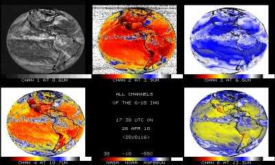
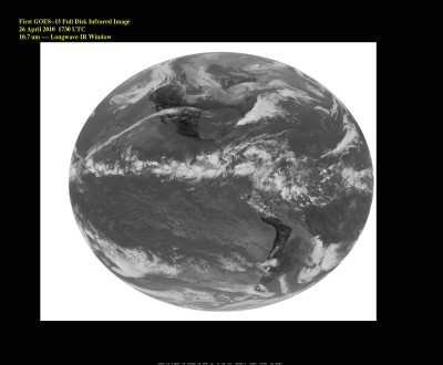
New Weather Satellite Captures Its First Thermal Images Of Earth

GOES-15, the final spacecraft in the latest series of NOAA geostationary satellites, took its first infrared image of Earth on April 26.


Image Courtesy NOAA

GOES spacecraft help NOAA forecasters track dangerous weather conditions and solar activity that can impact the satellite-based electronics and communications industry.

Infrared imagery is critical for accurate weather forecasts, revealing a range of information -- from the swirling motion of clouds and sea-surface temperatures, to moisture profiles of the atmosphere and the movement of smoke plumes from wildfires

GOES-15 was launched March 4, 2010, from Cape Canaveral, FL. After approximately five more months of tests, NASA will officially “hand over” the satellite to NOAA, which will place it in orbital storage mode. GOES-15 will be ready for activation if any of NOAA’s other four geostationary spacecraft experiences trouble.


Image Courtesy NOAA

NOAA works to understand and predict changes in the Earth’s environment, from the depths of the ocean, to the surface of the sun, and conserves and manages our coastal and marine resources.

FMI: www.noaa.gov

Advertisement

More News

ANN's Daily Aero-Linx (06.29.25)

Aero Linx: Transport Canada We are a federal institution, leading the Transport Canada portfolio and working with our partners. Transport Canada is responsible for transportation p>[...]

ANN's Daily Aero-Term (06.29.25): Gross Navigation Error (GNE)

Gross Navigation Error (GNE) A lateral deviation from a cleared track, normally in excess of 25 Nautical Miles (NM). More stringent standards (for example, 10NM in some parts of th>[...]

Classic Aero-TV: Anticipating Futurespace - Blue Origin Visits Airventure 2017

From AirVenture 2017 (YouTube Edition): Flight-Proven Booster On Display At AirVenture… EAA AirVenture Oshkosh is known primarily as a celebration of experimental and amateu>[...]

NTSB Final Report: Cirrus SR22

Aircraft Parachute System (CAPS) Was Deployed About 293 Ft Above Ground Level, Which Was Too Low To Allow For Full Deployment Of The Parachute System Analysis: The day before the a>[...]

Airborne Affordable Flyers 06.26.25: PA18 Upgrades, ‘Delta Force’, Rhinebeck

Also: 48th Annual Air Race Classic, Hot Air Balloon Fire, FAA v Banning 100LL, Complete Remote Pilot The news Piper PA-18 Super Cub owners have been waiting for has finally arrived>[...]

blog comments powered by Disqus


Advertisement

Advertisement

Podcasts

Advertisement

© 2007 - 2025 Web Development & Design by Pauli Systems, LC