Will Deploy Digital Infrastructure to Unlock New Drone Solutions
Airspace Link has partnered with Flagler County in Florida to launch the first-of-its-kind digital drone infrastructure in the sky, which will unlock new advanced, autonomous drone solutions to enhance both public safety and business operations, such as package delivery.
As a user of Esri ArcGIS online products, Flagler County was able to take advantage of the AirHub for Government solution and this new partnership is a first step for enabling businesses to safely deliver food, medical supplies, cargo and other essentials to communities around Flagler County with drones.
Flagler County will also incorporate the new capabilities into their own internal operations, which range from assessing coastal changes and impacts of major storms and hurricanes to saving lives from search and rescue operations. In addition, Flagler County’s drone pilot team and other commercial and recreational drone pilots in Flagler County will now be able to use AirHub for Pilots to get the necessary FAA authorizations to fly in the vicinity of the airport.
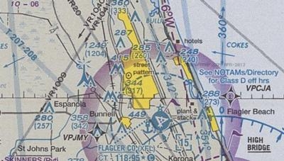
Airspace Link is an FAA-approved solution provider for Low Altitude Authorization and Notification Capability (LAANC) and at the end of September added another 133 airports, including Flagler Executive Airport, that are now included in this program. Flagler County drone pilots no longer need to wait to get approval to fly in controlled airspace, as the AirHub for Pilot application can authorize them in seconds.
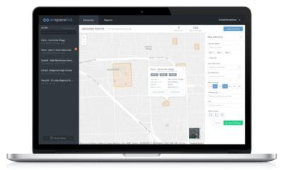
“In partnership with Airspace Link, we are in a better position to safely deploy our drone resources,” said Matthew Adams, GIS Analyst and UAS Coordinator for Flagler County. “The ground-based risk assessment and the ability to create public advisories allows our pilots to have optimal situational awareness when deploying drones to an incident.”
Airspace Link co-founder Ana Healander says drone technologies are rapidly advancing and the regulatory environment is opening up. This combination will drive the growth of drone usage throughout communities for all types of use cases. “In partnership with Flagler County, together we are supporting the drone industry as it grows and facilitating safer flights through our platform, AirHub,” said Healander.
Just last month, Flagler County used Airspace Link’s solution to create an advisory for the successful search and rescue mission of a missing kayaker, of Flagler Beach. Flagler County issued an advisory during the early hours of the search, and the drone team deployed when search helicopters had to leave the area for refueling. Matthew Adams says for future incidents, his team of drone pilots working in conjunction with Airspace Link will be deployed sooner as even more pilots become certified.

The partnership also implemented a layer of safety and protection measures for Flagler County drone pilots, all of whom are able to operate flights while understanding levels of ground risk related to what potential hazards they are flying over and near through AirHub for Pilots. Specifically, the initiative allows drone pilots the ability to stay compliant with airspace rules and regulations through Airspace Link’s Low Altitude Authorization and Notification Capability services.
 Airborne 07.21.25: Nighthawk!, Hartzell Expands, Deltahawk 350HP!