OSU Uses Unmanned Aircraft To Take Temperatures Up In The Air | Aero-News Network
Aero-News Network
RSS icon RSS feed
podcast icon MP3 podcast
Subscribe Aero-News e-mail Newsletter Subscribe

Airborne Unlimited -- Most Recent Daily Episodes

Episode Date

Airborne-Monday

Airborne-Tuesday

Airborne-Wednesday Airborne-Thursday

Airborne-Friday

Airborne On YouTube

Airborne-Unlimited-06.23.25

Airborne-NextGen-06.24.25

AirborneUnlimited-06.25.25

Airborne-AffordableFlyers-06.26.25

AirborneUnlimited-06.27.25

Mon, Apr 13, 2015

OSU Uses Unmanned Aircraft To Take Temperatures Up In The Air

Oregon State University Uses A UAV To Attain Precise Atmospheric Measurements Previously Not Available

For the first time, scientists at Oregon State University are measuring atmospheric temperatures with fiber optic thermometers suspended from unmanned aircraft, combining two emerging technologies to probe a poorly understood swath of Earth’s atmosphere.

With funding from the National Science Foundation, John Selker is buying two new unmanned aerial vehicles (UAVs) to loft sophisticated measuring instruments of his own design into an atmospheric zone that’s been hard to study until now.

“These two technologies together will add orders of magnitude to the precision and resolution of our atmospheric measurements,” said Selker, a hydrologist and professor in OSU’s College of Agricultural Sciences. “We’ll be able to take a continuous slice of data through space and time, getting information that no one has been able to capture before.”

The high-powered thermometers use a fiber-optic cable, similar to that used for telephone and internet communication. By measuring tiny pulses of light zipping along spun-glass strands, the fiber cables capture thousands of temperature readings along their length, detecting differences as slight as 0.01 degree Celsius.

The Earth’s surface and near atmosphere, which is up to about 1,000 meters above the ground, is a critical zone of feedbacks between air, water and earth, Selker said. “It’s where processes interact, where synergies occur. And temperature is a critical driver of these interactions.”

Until now, he said, scientists have had a hard time taking comprehensive measurements of the lower atmosphere.

Selker is a co-director of CTEMPs along with Scott Tyler of the University of Nevada. Wing is director of AirCTEMPs and directs UAV flights at OSU for agriculture, engineering, fish, wildlife and natural resource applications.

The $1.2 million NSF grant renewal will also fund CTEMPs’s purchase of other UAV-mountable instruments, including thermal imaging cameras and a small LIDAR, or laser-powered imaging tool, that captures three-dimensional measurements of landscape features.

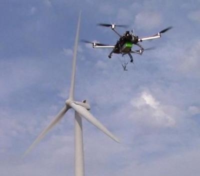
(Image of UAV flying over wind generator near Hermiston, OR captured from OSU website.)

FMI: www.oregonstate.edu

Advertisement

More News

Airborne 06.30.25: US v ADS-B Misuse, Nat’l STOL Fire, Volocopter Resumes

Also: Netherlands Donates 18 F16s, 2 737s Collide On Ramp, E-7 Wedgetail Cut, AgEagle's 100th In S Korea The Pilot and Aircraft Privacy Act was introduced in the House by Represent>[...]

NTSB Prelim: Piper PA-23

Pilot Also Reported That Due To A Fuel Leak, The Auxiliary Fuel Tanks Were Not Used On June 4, 2025, at 13:41 eastern daylight time, a Piper PA-23, N2109P, was substantially damage>[...]

ANN FAQ: Submit a News Story!

Have A Story That NEEDS To Be Featured On Aero-News? Here’s How To Submit A Story To Our Team Some of the greatest new stories ANN has ever covered have been submitted by our>[...]

Classic Aero-TV: One Man’s Vietnam

From 2023 (YouTube Edition): Reflections on War’s Collective Lessons and Cyclical Nature The exigencies of war ought be colorblind. Inane social-constructs the likes of racis>[...]

Klyde Morris (06.30.25)

What Goes Around, May Yet Come Back Around, Klyde FMI: www.klydemorris.com>[...]

blog comments powered by Disqus


Advertisement

Advertisement

Podcasts

Advertisement

© 2007 - 2025 Web Development & Design by Pauli Systems, LC