Wed, Sep 12, 2012
Storm Expected To Strengthen Into A Tropical Storm Soon
NASA's Hurricane and Severe Storm Sentinel (HS3) airborne mission sent an unmanned Global Hawk aircraft Tuesday morning to study newborn Tropical Depression 14 in the central Atlantic Ocean that seems primed for further development. The Global Hawk left NASA's Wallops Flight Facility on Wallops Island, VA, for a planned 26-hour flight to investigate the depression.
NASA's latest hurricane science field campaign began on September 7 when the Global Hawk flew over Hurricane Leslie in the Atlantic Ocean. HS3 marks the first time NASA is flying Global Hawks from the U.S. East Coast. According to Chris Naftel, project manager of NASA's Global Hawk program at NASA's Dryden Flight Research Center, Edwards Air Base, CA, the Global Hawk aircraft took off at 0706 EDT and headed for Tropical Depression 14, which at the time of take-off, was still a developing low pressure area called System 91L.
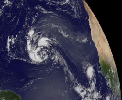
At 1100 EDT, Tropical Depression 14 was located near 16.3 North latitude and 43.1 West longitude, about 1,210 miles east of the Lesser Antilles. The depression had maximum sustained winds near 35 mph. It was moving to the west near 10 mph and had a minimum central pressure of 1006 millibars. The National Hurricane Center expects Tropical Depression 14 to strengthen into a tropical storm over the next 24 hours, and turn to the northwest.
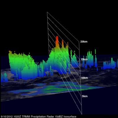
On Sept. 10, the Tropical Rainfall Measuring Mission (TRMM) satellite passed over Tropical Depression 14, when it was known as low pressure System 91L and data from TRMM's Microwave Imager (TMI) and Precipitation Radar (PR) were used to create a rainfall analysis. The data was overlaid on a combination infrared and visible image from TRMM's Visible and InfraRed Scanner (VIRS) and showed that System 91L was getting organized and that convective storms reaching heights of about 8.1 miles were dropping heavy rain to the northwest and northeast of the center of the circulation.
The HS3 mission targets the processes that underlie hurricane formation and intensity change. The data collected will help scientists decipher the relative roles of the large-scale environment and internal storm processes that shape these systems.
(Images provided by NASA Top: GOES Satellite image, Bottom: TRMM Satellite image)
More News
Also: Netherlands Donates 18 F16s, 2 737s Collide On Ramp, E-7 Wedgetail Cut, AgEagle's 100th In S Korea The Pilot and Aircraft Privacy Act was introduced in the House by Represent>[...]
Pilot Also Reported That Due To A Fuel Leak, The Auxiliary Fuel Tanks Were Not Used On June 4, 2025, at 13:41 eastern daylight time, a Piper PA-23, N2109P, was substantially damage>[...]
Have A Story That NEEDS To Be Featured On Aero-News? Here’s How To Submit A Story To Our Team Some of the greatest new stories ANN has ever covered have been submitted by our>[...]
From 2023 (YouTube Edition): Reflections on War’s Collective Lessons and Cyclical Nature The exigencies of war ought be colorblind. Inane social-constructs the likes of racis>[...]
What Goes Around, May Yet Come Back Around, Klyde FMI: www.klydemorris.com>[...]
 Airborne 06.30.25: US v ADS-B Misuse, Natl STOL Fire, Volocopter Resumes

