Refurbished Image Will Help In Plotting Future Landing
Sites
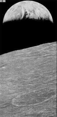 It's one of the most iconic images
ever captured, of any medium... and thanks to modern technology,
it's now ever more vivid than before. On Thursday, NASA released a
newly restored 42-year-old image, taken by the Lunar Orbiter 1
spacecraft, of Earth rising above the lunar surface in 1966.
It's one of the most iconic images
ever captured, of any medium... and thanks to modern technology,
it's now ever more vivid than before. On Thursday, NASA released a
newly restored 42-year-old image, taken by the Lunar Orbiter 1
spacecraft, of Earth rising above the lunar surface in 1966.
Using refurbished machinery and modern digital technology, NASA
produced the image at a much higher resolution than was possible
when it was originally taken. The data may help the next generation
of explorers as NASA prepares to return to the moon.
In the late 1960s, NASA sent five Lunar Orbiter missions to
photograph the surface of the moon and gain a better understanding
of the lunar environment in advance of the Apollo program. Data
were recorded on large magnetic tapes and transferred to
photographic film for scientific analysis. When these images were
first retrieved from lunar orbit, only a portion of their true
resolution was available because of the limited technology
available.
The Lunar Orbiter Image Recovery Project, located at NASA's Ames
Research Center at Moffett Field, CA is taking analog data from
original recorders used to store on tape and 1,500 of the original
tapes, converting the data into digital form, and reconstructing
the images. The restored image released Thursday confirms data from
the original tapes can be retrieved from the newly-restored tape
drives from the 1960s when combined with software from 2008.
"I'm glad that we could offer our services to the project team
and play a part in the recovery of such an historic image of the
moon," said Ames Director S. Pete Worden.
Future images will be made publicly available when they are
fully processed and calibrated. The intent of this project is to
facilitate, wherever possible, the broadest dissemination and
public use of these images.
"It's a tremendous feeling to restore a 40-year-old image and
know it can be useful to future explorers," said Gregory Schmidt,
deputy director of the NASA Lunar Science Institute at Ames. "Now
that we've demonstrated the capability to retrieve images, our goal
is to complete the tape drives' restoration and move toward
retrieving all of the images on the remaining tapes," he added.
As the images are processed, they will be submitted to the
Planetary Data System, which NASA's Space Science Mission
Directorate in Washington sponsors in cooperation with NASA's Jet
Propulsion Laboratory in Pasadena, CA. The images also will be
calibrated with standard mapping coordinates from the US Geological
Survey's Astrogeology Research Program in Flagstaff, AZ.
NASA will launch the Lunar Reconnaissance Orbiter in 2009 to map
the moon's surface. The restoration of the Lunar Orbiter images to
high quality images will provide the scientific community with a
baseline to measure and understand changes that have occurred on
the moon since the 1960s. These data could help mission planners
assess the long-term risk to lunar inhabitants from small meteor
impacts and establish longitude and latitude lines for lunar
mapping.
"This effort was made possible by the vision and dedication of
Apollo-era NASA employees, independent researchers, and a true
veteran team of engineers and young students," said Dennis Wingo,
the program lead for the project.
 NTSB Prelim: Lancair NLA-275-FR-C