Airbus And ZF To Develop Highly Precise End-To-End Autonomous Driving Solution | Aero-News Network
Aero-News Network
RSS icon RSS feed
podcast icon MP3 podcast
Subscribe Aero-News e-mail Newsletter Subscribe

Airborne Unlimited -- Most Recent Daily Episodes

Episode Date

Airborne-Monday

Airborne-Tuesday

Airborne-Wednesday Airborne-Thursday

Airborne-Friday

Airborne On YouTube

Airborne-Unlimited-09.01.25 (Holiday)

Airborne-Unlimited-09.02.25

AirborneUnlimited-08.27.25

Airborne-AffordableFlyers-08.28.25

AirborneUnlimited-08.22.25

Sat, Apr 20, 2019

Airbus And ZF To Develop Highly Precise End-To-End Autonomous Driving Solution

Will Utilize Radar Satellite Imagery Provided By Airbus

Airbus Defence and Space and ZF Friedrichshafen AG, a system provider for mobility, are collaborating to enrich and complement ZF on-board system to enhance autonomous driving by using Airbus satellite derived information.

Under this collaboration, Airbus and ZF are combining their capabilities and expertise to offer a reliable end-to-end solution for self-driving and self-positioning vehicles. To answer the extreme level of accuracy required, Airbus provides its unique high precise Ground Control Points (GCPs), calculated using radar satellite imagery, to support the fusion of ZF sensor data such as Lidar and Radar. In addition, the GCPs serve as independent data source to improve and validate the accuracy of mobile mapping data.

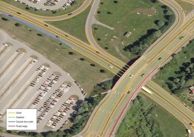
Furthermore Airbus investigates generation of High Definition maps (HD maps) based on aerial and space borne approach, to complement ZF semantic cards. HD Maps are key to ensure the guiding route, as they build an important link between mobile mapping data and global positioning systems. They contain more information than just the road itself, as lanes, the radius of curves, lane widths, street signs, bridges, and buildings, as well as their distance from one another. Both remote sensed information GCPs and HD maps will be integrated as foundation layers into the “ZF AD Environment” – an enhanced HD maps solution ZF will present soon – where all needed information for autonomous driving will be implemented in a cloud based system.

Autonomous driving is a new, enthusing and challenging market for Airbus, as the highest level of autonomy requires the highest maps precision.

(Image provided with Airbus news release)

FMI: www.airbus.com

Advertisement

More News

YFQ-42A Collaborative Combat Aircraft Starts Flight Testing

Newest USAF Drone Begins Process in Earnest The YFQ-42A Collaborative Combat Aircraft has begun its flight testing in coordination with the U.S. Air Force, taking a vital step towa>[...]

Aero-News: Quote of the Day (09.02.25)

“What a great moment for the U.S. Air Force and for GA-ASI. It’s been our collaboration that enabled us to build and fly the YFQ-42A in just over a year. It’s an >[...]

Delta Settles Fuel Dump Lawsuit in a $78M Handshake

Airline Pilots Jettisoned 15,000 Pounds of Fuel Over Populated Areas Five years after one of its Boeing 777s dumped 15,000 pounds of jet fuel onto neighborhoods, Delta Air Lines ha>[...]

Watchdog Warns of Another Understaffed FAA Program: Meteorology

GAO Report Says that Only 69 Aviation Meteorologists Work Alongside ATC A federal watchdog says the FAA is running the nation’s air traffic system with fewer weather experts >[...]

Airborne 08.27.25: Air Race Tkt Discounts, Europe AvGas, Deportation Flights?

Also: 500-Aircraft Deal With China, Florida ANG's F-35, FAA Denies Petition, UC Central Arkansas Aviation Academy The Reno Air Racing Association (RARA) is offering its apologies t>[...]

blog comments powered by Disqus


Advertisement

Advertisement

Podcasts

Advertisement

© 2007 - 2025 Web Development & Design by Pauli Systems, LC