Utah Man Lends Drone, Expertise To Hawaiian Officials Tracking Lava Flows | Aero-News Network
Aero-News Network
RSS icon RSS feed
podcast icon MP3 podcast
Subscribe Aero-News e-mail Newsletter Subscribe

Airborne Unlimited -- Most Recent Daily Episodes

Episode Date

Airborne-Monday

Airborne-Tuesday

Airborne-Wednesday Airborne-Thursday

Airborne-Friday

Airborne On YouTube

Airborne-Unlimited-10.20.25

AirborneNextGen-
10.21.25

Airborne-Unlimited-10.22.25

Airborne-FltTraining-10.23.25

AirborneUnlimited-10.17.25

Sun, May 27, 2018

Utah Man Lends Drone, Expertise To Hawaiian Officials Tracking Lava Flows

Aircraft Help First Responders, Others Make Critical Decisions During The Eruptions

The vice president for technology for Rocky Mountain Unmanned Systems Jon McBride recently returned from Hawaii, but his trip was not exactly an exotic vacation.

McBride has family on the island of Hawaii, where the Kilauea volcano has been erupting for several weeks. While McBride's family was not directly threatened by the lava flows, they did feel some of the impacts of the eruptions on the island.

But while he was there, McBride used drones to help out researchers, first responders and city officials, according to a report from television station KSL. He worked with the Center for Robot-Assisted Search and Rescue as well as the Hilo Fire Department and other agencies to provide data related to the lava flows.

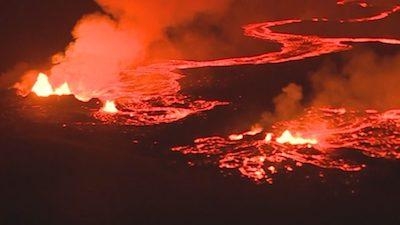
The aircraft were able to track the flows and identify hotspots in areas where the magma was no longer glowing red but was still giving off significant heat. Thermal imagers and GPS positioning helped determine the direction and speed of the lava flows, assisting local officials in making decisions about evacuations.

Drones are also being used to identify roads that have been closed by lava flows and rerouting traffic around those areas.

(Image from Big Island Video News YouTube video)

FMI: Original report

Advertisement

More News

ANN's Daily Aero-Term (10.26.25): Hazardous Weather Information

Hazardous Weather Information Summary of significant meteorological information (SIGMET/WS), convective significant meteorological information (convective SIGMET/WST), urgent pilot>[...]

ANN's Daily Aero-Linx (10.26.25)

Aero Linx: FAI Hang Gliding and Paragliding Commission (CIVL) The mission of the FAI Hang Gliding and Paragliding Commission (CIVL) is to administer hang gliding and paragliding on>[...]

Aero-News: Quote of the Day (10.26.25)

“This partnership with Archer will accelerate Korea’s leadership in next-generation air mobility. By combining Archer’s industry-leading eVTOL technology with Kor>[...]

Classic Aero-TV: Of Rotors, Ribs, World Records, and a Growing Phenomenon

From 2023 (YouTube Edition): Indiana’s Rotors ‘n Ribs Helicopter Fly-In Celebrates 7th Year Held annually for the last seven-years at Indiana’s Goshen Municipal A>[...]

NTSB Prelim: Toop Thomas A Glasair Super II FT

The Airplane’s Left Wing Struck The Windsock Pole Located Near The Runway, Which Had Been Constructed From A Telephone Pole On September 27, 2025, at 1418 eastern daylight ti>[...]

blog comments powered by Disqus


Advertisement

Advertisement

Podcasts

Advertisement

© 2007 - 2025 Web Development & Design by Pauli Systems, LC