High Resolution Aerial Imagery Added To True Flight Cheetah Portable MFD | Aero-News Network
Aero-News Network
RSS icon RSS feed
podcast icon MP3 podcast
Subscribe Aero-News e-mail Newsletter Subscribe

Airborne Unlimited -- Most Recent Daily Episodes

Episode Date

Airborne-Monday

Airborne-Tuesday

Airborne-Wednesday Airborne-Thursday

Airborne-Friday

Airborne On YouTube

Airborne-Unlimited-12.02.24

Airborne-NextGen-12.03.24

Airborne-Unlimited-12.04.24

Airborne Flt Training-12.05.24

Airborne-Unlimited-12.06.24

Sat, Jul 24, 2010

High Resolution Aerial Imagery Added To True Flight Cheetah Portable MFD

Resolution At 21 Feet For The Lower 48 United States

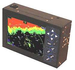
High-resolution aerial imagery mapping for the entire contiguous lower 48 states has been incorporated by True Flight for its line of portable Flight Cheetah multi-function GPS displays. In an announcement Thursday, True Flight said the addition of aerial imagery demonstrates True Flight's ability to bring to market technologies that will have a substantial impact on safety, yet remain affordable to every cockpit.


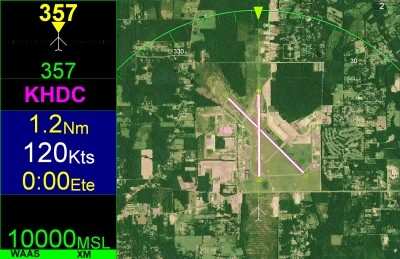
Aerial Image Screen Shot

The Flight Cheetah MFD will allow pilots to overlay aerial imagery providing a view of the terrain conditions below.  Should an emergency happen in IFR conditions or at night and an airport is not within reach, this unique ability to separate areas of buildings and trees from fields could be a life saving feature.  The aerial maps are at a resolution of 21 feet for the entire United States. The high-resolution aerial imagery will replace the satellite imagery previously provided to True Flight customers.

This feature will allow pilots to view the terrain below in direct relation to their current aircraft position. Pilots will also have the option to overlay any type of navigational information and/or weather on top of the aerial maps.


True Flight Cheetah MFD

"I can tell you firsthand having dealt with an engine problem at night many years ago, all those jokes about waiting till you get close to the ground and turning on your landing light and if you don't like what you see turning it off loses something in translation when it is actually happening to you. The addition of high resolution aerial terrain imagery will substantially improve situational awareness and safety to new highs in aviation", said Robert Kalberer president of True Flight.

Aerial imagery has already been released for Florida, Georgia, Mississippi, Alabama, and Louisiana. The aerial imagery will be released for the rest of the US over the next two months several states at a time.

FMI: www.aviationsafety.com

Advertisement

More News

ANN's Daily Aero-Linx (12.05.24)

Aero Linx: Canadian Bushplane Heritage Centre Visit the Canadian Bushplane Heritage Centre. The only museum of its kind in Canada. A world class museum connecting people of all age>[...]

ANN's Daily Aero-Term (12.05.24): Chaff

Chaff Thin, narrow metallic reflectors of various lengths and frequency responses, used to reflect radar energy. These reflectors, when dropped from aircraft and allowed to drift d>[...]

Airborne 12.02.24: Electra FG EIS, Prez Osprey Problems, Starship Wants 25

Also: EAA Ray Foundation, MagniX Records, Ruko U11MINI Drone, RCAF PC-21s Elektra Solar recently put the first aircraft from its Elektra Trainer Fixed-Gear (FG) family into service>[...]

Airborne 11.27.24: CAP Tragedy, Gulfstream Milestone, Van Celebrates His 85th

Also: ANN/Airborne Holiday Schedule, UT NG Gets New Apaches, UK Airport Reopening, Laser v Helo A Civil Air Patrol search and rescue training flight over steep and rugged terrain e>[...]

ANN's Daily Aero-Linx (12.06.24)

Aero Linx: National Air Traffic Controllers Association (NATCA) NATCA members embrace new technology and are eager to use the most efficient and modern procedures available. First >[...]

blog comments powered by Disqus


Advertisement

Advertisement

Podcasts

Advertisement

© 2007 - 2024 Web Development & Design by Pauli Systems, LC