ForeFlight Updates Wind Layers, Civil Twilight | Aero-News Network
Aero-News Network
RSS icon RSS feed
podcast icon MP3 podcast
Subscribe Aero-News e-mail Newsletter Subscribe

Airborne Unlimited -- Most Recent Daily Episodes

Episode Date

Airborne-Monday

Airborne-Tuesday

Airborne-Wednesday Airborne-Thursday

Airborne-Friday

Airborne On YouTube

Airborne-Unlimited-11.24.25

AirborneNextGen-
11.18.25

Airborne-Unlimited-11.19.25

Airborne-AffordableFlyers-11.20.25

AirborneUnlimited-11.21.25

LIVE MOSAIC Town Hall (Archived): www.airborne-live.net

Wed, Sep 25, 2024

ForeFlight Updates Wind Layers, Civil Twilight

Another Premium Features Comes to 'Performance Plus' Tier

ForeFlight has once again updated its 'FPL Drawer' with some modest enhancements for subscribers, but as per usual, some of them will be tied to the firm's pricier subscription tiers.

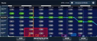
Most notable is the addition of a nifty strip of data while quickly keying in waypoints to the standard flight planning window, telling pilots the essentials about their route like distance, ETE/ETA, fuel burn, winds, and corridor width. For those who find it a little obtrusive, the window can be compacted to gain additional room for the map underneath. The 'flight information strip' is also available in the Navlog Profile View, too. Improving further on the livability of ForeFlight6's planning capacity is a quick-access button in the map layers butt on the upper right of the profile window. That allows pilots to quickly check the side profile of their flight, with improved software reportedly giving a smoother, easier experience overall.

Instructors will be happy to see ForeFlight's handling of Civil Twilight tracking, too. Now, users can "Accurately log day and night hours using enhanced solar data, including morning civil twilight, sunrise, sunset, and evening civil twilight for any airport worldwide." ForeFlight can now clearly delineate user's flight time before Civil Twilight, by calculating their exposure to the sun by location, extrapolating down to the minute when the sun finally drops 6º below the horizon. Solar info can be checked from airport information by tapping the small grey arrow next to the sunrise and sunset times below the name.

Additional layers have come to Profile View, too, enhancing flight planning with new headwind, tailwind, and estimated groundspeed layers. The improvements will build on the accuracy of altitude insights and rout analysis, while adding some very easily parsed color coding to show favorable conditions wherever they exist. The info is drawn from the same data as ForeFlight's Dynamic Winds and Temperatures layers, so the info shown on screen will always be the most accurate approximation of real-world conditions the app can provide.

Some additional improvements include a map setting to show low-altitude hazards, from 100 to 500 feet; and VFR Charts for most of North Africa, and Japan. Rogers' African charts include the Middle East to Syria, while the new Japanese charts come from Airman's Information Service, Ltd.. On top of all that, ForeFlight has improved on their weight and balance suite with a graphic representation of stations, seats, and layouts. The system works alongside the Web version, too, allowing users to make use of larger, comfier computer screens should they prefer.

FMI: www.foreflight.com

Advertisement

More News

Airborne 11.24.25: ANN's 30th!, Starship’s V3 Booster Boom, Earhart Records

Also: 1st-Ever Space Crime Was a Fraud, IAE Buys Diamonds, Kennon Bows Out, Perseverance Rover An interesting moment came about this past Sunday as ANN CEO, Jim Campbell, noted tha>[...]

ANN FAQ: Submit a News Story!

Have A Story That NEEDS To Be Featured On Aero-News? Here’s How To Submit A Story To Our Team Some of the greatest new stories ANN has ever covered have been submitted by our>[...]

Classic Aero-TV: DeltaHawk Aero Engine Defies Convention

From 2023 (YouTube Edition): Deviation from the Historical Mean Racine, Wisconsin-based DeltaHawk is a privately-held manufacturer of reciprocating engines for aircraft and hybrid >[...]

NTSB Final Report: Glasair GlaStar

Smoke Began Entering The Cockpit During The Landing Flare, And Then The Pilot Noticed Flames On The Right Side Of The Airplane Analysis: The pilot reported that about 30 minutes in>[...]

ANN's Daily Aero-Term (11.22.25): Remote Communications Outlet (RCO)

Remote Communications Outlet (RCO) An unmanned communications facility remotely controlled by air traffic personnel. RCOs serve FSSs. Remote Transmitter/Receivers (RTR) serve termi>[...]

blog comments powered by Disqus


Advertisement

Advertisement

Podcasts

Advertisement

© 2007 - 2025 Web Development & Design by Pauli Systems, LC