Unmanned Aircraft To Gain Access To Precise Weather Data | Aero-News Network
Aero-News Network
RSS icon RSS feed
podcast icon MP3 podcast
Subscribe Aero-News e-mail Newsletter Subscribe

Airborne Unlimited -- Most Recent Daily Episodes

Episode Date

Airborne-Monday

Airborne-Tuesday

Airborne-Wednesday Airborne-Thursday

Airborne-Friday

Airborne On YouTube

Airborne-Unlimited-08.25.25

Airborne-NextGen-08.26.25

AirborneUnlimited-08.27.25

Airborne-AffordableFlyers-08.28.25

AirborneUnlimited-08.22.25

Fri, Aug 05, 2016

Unmanned Aircraft To Gain Access To Precise Weather Data

The Weather Company And AirMap Join To Deliver Real-time Hyperlocal Weather Data

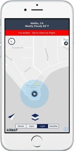
The Weather Company has announced that they will be working with AirMap to allow AirMap to deliver real-time hyperlocal weather data directly to drone operators. As drone technology moves toward increasingly sophisticated, autonomous operations, precise and accurate weather data will be critical for safe and efficient operations. Drone operators will be able to access the weather data from The Weather Company via AirMap's app for iOS and Apple Watch as well as AirMap's APIs for developers.

The FAA recently published a new section of the Federal Aviation Regulations, Part 107, that defines new rules for commercial drone flights. As part of the new regulations, remote pilots of unmanned aircrafts are required to be familiar with available weather information prior to flight departure.

"Part 107 is a major milestone in drone regulation for visual line-of-sight operations," said Ben Marcus, CEO of AirMap and an airline transport rated pilot and flight instructor. "The availability of real-time hyperlocal weather data from The Weather Company will help today's drone pilots avoid hazardous and severe weather, and will be absolutely critical for safe, efficient flight planning and operations of more autonomous, beyond visual-line-of-sight drones."

The Weather Company's forecasting platform produces precise weather forecasts every fifteen minutes for 2.2 billion locations worldwide. Drone operators will gain access to real-time data such as current and forecasted conditions, including temperature, precipitation, pressure, cloud cover, and more. This high-performance, cloud-based platform provides an average of 20 million forecasts daily.

"As a result of this AirMap deal, we can help drone operators not only be in compliance with Part 107 regulations, but also be able to leverage precise and accurate hyperlocal weather data to help guide decision-making and help work towards the safety, efficiency, and performance of their unmanned aircraft," said Mark Gildersleeve, president of business solutions at The Weather Company.

(Image provided with The Weather Company news release)

FMI: www.theweathercompany.com

Advertisement

More News

Aero-News: Quote of the Day (08.28.25)

“We have seen astounding demand for the G800, and the entire Gulfstream team is excited to begin making deliveries to our customers. The G800 is entering service with extraor>[...]

ANN's Daily Aero-Linx (08.28.25)

Aero Linx: Recreational Aviation Australia (RAAus) Recreational Aviation Australia is progressively working towards improving safety outcomes through a holistic approach to safety >[...]

Classic Klyde Morris (08.25.25)

Classic Klyde Morris From 11.07.16 (and Remembering Bob...) FMI: www.klydemorris.com>[...]

Airborne 08.25.25: Zenith Homecoming, VP Racing, Affordable Flying Expo 2025

Also: GADFLY AI-Driven Engine Analysis, Knockoff Iranian Drones, Russian Surveillance, 40 NASA Missions Chopped This year’s Zenith Homecoming event will soon be taking off at>[...]

Airborne 08.22.25: ARC Spinoff, Nat'l Championship Air Races, Hawkins Accident

Also: H55 Completes American Tour, Robinson Trade-Ins, Retired AV-8B Harrier, NS-35 Mission Organizers of the iconic annual Air Race Classic will soon be opening registration for t>[...]

blog comments powered by Disqus


Advertisement

Advertisement

Podcasts

Advertisement

© 2007 - 2025 Web Development & Design by Pauli Systems, LC