Mon, Sep 09, 2019
The Copernicus Satellite Will Now Undergo Extensive Testing, With Its Launch Set For November 2020
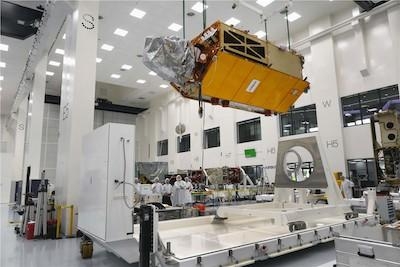
Airbus has completed the ocean satellite ‘Copernicus Sentinel-6A’, and is now sending it on its first journey. Its destination: Ottobrunn near Munich in Germany, where over the next six months the satellite will undergo an extensive series of tests at Industrieanlagen Betriebsgesellschaft mbH (IABG) to prove its readiness for space.
‘Copernicus Sentinel-6’ will carry out high-precision measurements of ocean surface topography. The satellite will measure its distance to the ocean surface with an accuracy of a few centimetres and, over a mission lasting up to seven years, use this data to map it, repeating the cycle every 10 days. It will document changes in sea-surface height, record and analyse variations in sea levels and observe ocean currents. Exact observations of changes in sea-surface height provide insights into global sea levels, the speed and direction of ocean currents, and ocean heat storage. These measurements are vital for modelling the oceans and predicting rises in sea levels.
The findings will enable governments and institutions to establish effective protection for coastal regions. The data will be invaluable not only for disaster relief organisations, but also for authorities involved in urban planning, securing buildings or commissioning dykes.
Some data suggests that global sea levels are currently rising by an average of 3.3 millimetres (0.13 inches) a year, which could potentially have dramatic consequences for countries with densely populated coastal areas.
Two Sentinel-6 satellites for the European Copernicus Programme for environment and security are currently being developed under Airbus’s industrial leadership. While it is one of the European Union’s family of Copernicus satellite missions, Sentinel-6 is also being realised thanks to an international cooperation between ESA, NASA, NOAA and Eumetsat.
Each satellite weighs approximately 1.5 metric tons. From November 2020, Sentinel-6A will be the first of the two Sentinel-6 satellites to continue collecting satellite-based measurements of the oceans’ surfaces, a task that began in 1992. Sentinel-6B is then expected to follow in 2025.
(Image provided with Airbus Space news release)
More News
Its Offerings Are Lighter, Cleaner, and Now Pushing Past 1,000nm on SAF Jet Fuel DeltaHawk’s diesel-powered aircraft lineup has seen incredible upgrades over the last few yea>[...]
The Airplane Experienced A Total Loss Of Engine Power On December 3, 2025, about 1600 central standard time, a Mooney Aircraft Corp. M20K, N57229, was substantially damaged when it>[...]
Make Sure You NEVER Miss A New Story From Aero-News Network Do you ever feel like you never see posts from a certain person or page on Facebook or Instagram? Here’s how you c>[...]
Aero Linx: European Society of Aerospace Medicine (ESAM) As a pan-European, independent forum, it works to promote the safety and health of all persons involved in aviation and spa>[...]
“We are excited to see Wisk achieve this milestone, and I’m so proud of the team that made it possible. The team at Wisk has built advanced technologies across flight c>[...]
 Aero-TV: DeltaHawks Diesel Power Steps Into the Spotlight

