Thu, Feb 28, 2019
Will Detect Radio Frequency Signals From Space
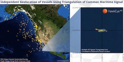
HawkEye 360 Inc. has successfully commissioned its three Pathfinder satellites and begun geolocating radio frequency (RF) signals. HawkEye 360 satellites fly in a commercially unique formation that independently pinpoints the geographical origin of a wide range of RF signals. Early test results have already demonstrated successful geolocation of VHF Channels 16 and 70, EPIRB, and AIS signals as well as identifying marine radar signals. This proprietary source of data enables HawkEye 360 to locate and analyze previously undetected activity, providing new insights for maritime, emergency response, and spectrum analysis applications.
"We are generating an entirely new data source for important commercial, defense, and intelligence applications around the world," said HawkEye 360 Chief Executive Officer John Serafini. "As the first to be delivering this type of commercial data, HawkEye 360 will help our customers make more timely and precise decisions. Our team has shown unbelievable dedication and passion to reach a new milestone in space technology in just a few short years."
In the maritime sector, data gathered by HawkEye 360 can provide visibility for law enforcement into suspicious vessel behavior, giving them better information in their pursuit of illicit activity. Search and rescue efforts can be aided through geolocation of emergency beacons, even when broadcasting incorrect GPS coordinates. HawkEye 360's spectrum analysis can survey usage of RF bands to maximize communication spectrum and avoid interference.
"We are thrilled by the breadth of RF data our Pathfinder satellites are gathering from hundreds of miles above the Earth," said Rob Rainhart, Executive Vice President of Engineering for HawkEye 360. "We've achieved much with our early testing and continue to expand the types of signals we can geolocate. It's exciting to have strong momentum as we prepare to go to market with a full suite of commercially available analytics products over the course of 2019."
The company is using the Pathfinder satellites to perform data verification and strategic demonstrations with select customers. These efforts will inform enhancements to the next cluster of satellites currently under development for launch later this year. This next-generation of satellites will broaden the signal range, on-board-processing, and data capabilities as HawkEye 360 expands the constellation to achieve near persistent global coverage.
(Image provided with HawkEye 360 news release)
More News
Aero Linx: Vintage Sailplane Association The purpose of the Vintage Sailplane Association (VSA) is to promote the acquisition, restoration and flying of vintage sailplanes by its m>[...]
Smoke Began Entering The Cockpit During The Landing Flare, And Then The Pilot Noticed Flames... Analysis: The pilot reported that about 30 minutes into the local flight, he heard s>[...]
Make Sure You NEVER Miss A New Story From Aero-News Network Do you ever feel like you never see posts from a certain person or page on Facebook or Instagram? Here’s how you c>[...]
From 2010 (YouTube Edition): The Red Tail Project Continues Effort Towards ‘Rise Above Program’ The Red Tail Project is a true example of this unbreakable spirit. In 20>[...]
Also: 1st-Ever Space Crime Was a Fraud, IAE Buys Diamonds, Kennon Bows Out, Perseverance Rover An interesting moment came about this past Sunday as ANN CEO, Jim Campbell, noted tha>[...]
 ANN's Daily Aero-Linx (11.25.25)

