QinetiQ Completes First Flight Of UK Agricultural Monitoring UAV | Aero-News Network
Aero-News Network
RSS icon RSS feed
podcast icon MP3 podcast
Subscribe Aero-News e-mail Newsletter Subscribe

Airborne Unlimited -- Most Recent Daily Episodes

Episode Date

Airborne-Monday

Airborne-Tuesday

Airborne-Wednesday Airborne-Thursday

Airborne-Friday

Airborne On YouTube

Airborne-Unlimited-07.21.25

Airborne-Unlimited-07.22.25

AirborneUnlimited-07.23.25

Airborne-Unlimited-07.24.25

AirborneUnlimited-07.25.25

Fri, Aug 08, 2008

QinetiQ Completes First Flight Of UK Agricultural Monitoring UAV

U-MAP Program Aims To Monitor Land Suitability

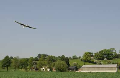
QinetiQ, working in partnership with Aberystwyth University's new biosciences centre IBERS, has successfully completed the UK's first flight of an autonomous unmanned aerial vehicle (UAV) for agricultural monitoring.

The flight was the culmination of phase one of the pioneering U-MAP program, a project supported by the Welsh Assembly Government. U-MAP (UAVs for Managing Agricultural Practice) has demonstrated the feasibility of using a UAV to deliver high resolution images to the agricultural, forestry and environmental monitoring sectors.

Farmers and foresters increasingly need accurate and timely information on the state of the land they occupy. For example by mapping the fertilizer requirements of arable crops, farmers can ensure they only apply the precise amount of fertilizer required, saving them money and preventing the pollution that occurs when nitrate fertilizers are over-applied.

The QinetiQ team acted as systems integrator for the specially adapted UAV platform and flew a total of more than 15 flights during the "work-up" phase and in support of data gathering. The UAV captured specialized video images that were used to create NDVI (normalised difference vegetation index) maps – sensitive indicators of the amount of vegetation present that can be used to determine fertilizer requirements.

"The UMAP project brings together emerging UAV technology with the growing need for farmers to fully understand the land they have under cultivation," commented Clive Richardson, Chief Operating Officer for QinetiQ's EMEA business. "With these recent flights we have successfully shown that UAVs are an affordable and flexible alternative to manned aircraft and satellites for the remote sensing of agricultural land."

FMI: www.qinetiq.com

Advertisement

More News

Airborne 07.21.25: Nighthawk!, Hartzell Expands, Deltahawk 350HP!

Also: New Lakeland Fly-in!, Gleim's DPE, MOSAIC! Nearly three-quarters of a century in the making, EAA is excited about the future… especially with the potential of a MOSAIC>[...]

ANN's Daily Aero-Term (07.27.25): Estimated (EST)

Estimated (EST) -When used in NOTAMs “EST” is a contraction that is used by the issuing authority only when the condition is expected to return to service prior to the >[...]

ANN's Daily Aero-Linx (07.27.25)

Aero Linx: Regional Airline Association (RAA) Regional airlines provide critical links connecting communities throughout North America to the national and international air transpo>[...]

NTSB Final Report: Luce Buttercup

The Airplane Broke Up In Flight And Descended To The Ground. The Debris Path Extended For About 1,435 Ft. Analysis: The pilot, who was the owner and builder of the experimental, am>[...]

Classic Aero-TV: 'That's All Brother'-Restoring a True Piece of Military History

From 2015 (YouTube version): History Comes Alive Thanks to A Magnificent CAF Effort The story of the Douglas C-47 named, “That’s all Brother,” is fascinating from>[...]

blog comments powered by Disqus


Advertisement

Advertisement

Podcasts

Advertisement

© 2007 - 2025 Web Development & Design by Pauli Systems, LC