iFlightPlanner Adds Graphical SUA & Class Airspace, Full-Screen Maps | Aero-News Network
Aero-News Network
RSS icon RSS feed
podcast icon MP3 podcast
Subscribe Aero-News e-mail Newsletter Subscribe

Airborne Unlimited -- Most Recent Daily Episodes

Episode Date

Airborne-Monday

Airborne-Tuesday

Airborne-Wednesday Airborne-Thursday

Airborne-Friday

Airborne On YouTube

Airborne-Unlimited-07.21.25

Airborne-Unlimited-07.22.25

AirborneUnlimited-07.23.25

Airborne-Unlimited-07.24.25

AirborneUnlimited-07.25.25

Fri, Jun 14, 2013

iFlightPlanner Adds Graphical SUA & Class Airspace, Full-Screen Maps

Online Forums Also Now Part Of The Package

In its latest release, all iFlightPlanner.com maps, including the VFR and IFR charts available at iFlightPlanner.com/AviationCharts and those found in the Flight Wizard, now feature vertical airspace profiles and a completely redesigned mapping interface with full-screen viewing capability.

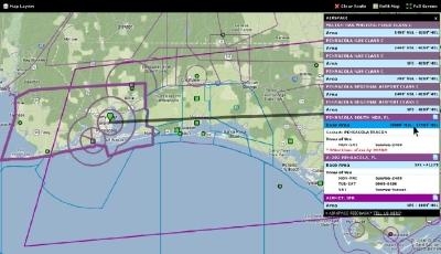
Special Use Airspace (NSA, MOA, Alert, Warning, Prohibited & Restricted Areas) as well as Class B, C, D and E airspace information is accessible by an intuitive point-and-click method that provides access to a direct data feed from the Federal Aviation Administration (FAA) through iFlightPlanner, which includes distinct airspace shapes, vertical altitude limits, times of use and contact information for each. Previously available graphical AIRMETs, SIGMETs and TFRs were also integrated into the upgraded airspace and mapping functionality.

To view the airspace information, simply left or right click anywhere on a map and select the “View Airspace Info” option. When the airspace pop-up window appears on the right side of the screen, pilots can then hover over the “Area” or “Base Area” line item to see that specific airspace highlighted on the map or click the page icon to access the area’s full text definition.

The new features, like all those now developed for iFlightPlanner.com, mobile.iFlightPlanner.com and iFlightPlanner for iPad presented by Sennheiser, were the direct result of feedback from a vocal group of new members. “We’ve made it known since the beginning that our members have a direct line of communication with the iFlightPlanner Crew to help shape the future of our products,” said Andy Matthews, iFlightPlanner’s Co-Founder & Director of Business Development. “We received a significant number of suggestions over the past few months for SUA and class airspace functionality to be added to our mapping technology on iFlightPlanner.com. That functionality, combined with the ability to view our online maps in a full-screen mode, have been delivered in a very short period of time with an overwhelmingly positive response!”

With the addition of the new SUA and Class Airspace layers iFlightPlanner has launched an initiative where new iFlightPlanner Premium features will be available to all iFlightPlanner members, Free and Premium, at no cost for a 60- day comment and feedback period before they are moved into iFlightPlanner Premium. The trials will revolve around the new iFlightPlanner Forums that were launched in conjunction with this update, and the iFlightPlanner Crew is encouraging its members to “kick the tires and put each new feature through the ringer,” said iFlightPlanner’s Co- Founder & Director of Technology, John Burnside. “Let us know what you like, what needs to be tweaked and what we can continue to do to make iFlightPlanner the best and most comprehensive resource for you!”

(Screenshot Image provided by iFlightPlanner)

FMI: www.iFlightPlanner.com

Advertisement

More News

Airborne 07.21.25: Nighthawk!, Hartzell Expands, Deltahawk 350HP!

Also: New Lakeland Fly-in!, Gleim's DPE, MOSAIC! Nearly three-quarters of a century in the making, EAA is excited about the future… especially with the potential of a MOSAIC>[...]

ANN's Daily Aero-Term (07.27.25): Estimated (EST)

Estimated (EST) -When used in NOTAMs “EST” is a contraction that is used by the issuing authority only when the condition is expected to return to service prior to the >[...]

ANN's Daily Aero-Linx (07.27.25)

Aero Linx: Regional Airline Association (RAA) Regional airlines provide critical links connecting communities throughout North America to the national and international air transpo>[...]

NTSB Final Report: Luce Buttercup

The Airplane Broke Up In Flight And Descended To The Ground. The Debris Path Extended For About 1,435 Ft. Analysis: The pilot, who was the owner and builder of the experimental, am>[...]

Classic Aero-TV: 'That's All Brother'-Restoring a True Piece of Military History

From 2015 (YouTube version): History Comes Alive Thanks to A Magnificent CAF Effort The story of the Douglas C-47 named, “That’s all Brother,” is fascinating from>[...]

blog comments powered by Disqus


Advertisement

Advertisement

Podcasts

Advertisement

© 2007 - 2025 Web Development & Design by Pauli Systems, LC