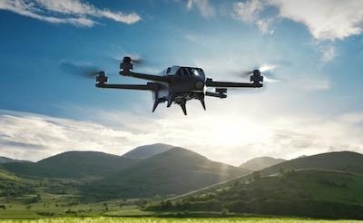
Bluegrass Fields Is A Fully Integrated Solution Designed For Both Crop Mapping And Scouting
European drone group Parrot has introduced Bluegrass Fields, an end-to-end agriculture drone solution, which provides farmers, agronomists and researchers with the insights they need to boost the quality of their crops and maximize yields.

Part of the Parrot Business Solutions portfolio, Parrot Bluegrass Fields brings together today’s popular Parrot Bluegrass drone with the all-new ParrotFields mobile mapping app and Pix4Dfields desktop and cloud-based drone mapping software. “Parrot Bluegrass Fields makes it easier than ever before for professionals such as agronomists, farmers and researchers to map their fields, to scout crops from the air, and to then act directly on the insights they gain,” said Jean-Thomas Celette, Chief Strategy & Product Officer for Parrot Business Solutions. “The seamlessness of this end-to-end solution also showcases the unique strength of Parrot Business Solutions, as it builds directly on Parrot Group’s drone, sensor and software expertise in the agricultural sector.”
The rugged, easy-to-fly Parrot Bluegrass agriculture drone features a robust carbon-fiber structure, a flight time of up to 25 minutes (three batteries are included), flight coverage of up to 160 acres per flight at 400 ft, and a handy, tailor-made backpack for easy transportation. Its vertical take-off and landing ensure efficient operations, even in confined areas. With its integrated industry-leading multispectral Parrot Sequoia sensor and a 14 MP front RGB camera to shoot both pictures and videos in full HD (1080p), Parrot Bluegrass Fields is a truly multipurpose solution that suits both crop mapping and visual scouting.
Parrot Bluegrass Fields features one-year access to the all-new ParrotFields mobile mapping app that simplifies the entire in-field workflow—from the planning of automatic mapping flights, to generating real-time NDVI maps, unique semi-automated scouting flights over areas of interest (including on-demand photo and video capture) and, when ground truthing, the adding of text annotations and photos shot from the ground.
In addition to the Parrot Fields mobile mapping app, Parrot Bluegrass Fields includes one full year of access to Pix4Dfields desktop and cloud software for further in-depth analysis of the crop data gathered, including the creation of index maps for crop performance analysis and prescription maps that can be easily exported to tractors and Farm Management Information Systems.
Parrot Bluegrass Fields includes:
- 1 Parrot Bluegrass quadcopter drone
- 1 Parrot Sequoia multispectral sensor (integrated in drone)
- 1 Parrot Skycontroller 2
- 1 Parrot Skycontroller 2 charger
- 1 backpack
- 3 batteries
- 1 battery charger
- 4 spare propellers
- 1 USB cable for Micro-USB
- One-year subscription to ParrotFields
- One-year subscription to Pix4Dfields
Parrot Bluegrass Fields is available for pre-sale immediately via official Parrot Business Solutions distribution partners. Shipping will begin at the end of November
(Image provided with Parrot group news release)
 NTSB Final Report: Aviat A1
 ANN's Daily Aero-Linx (07.08.25)
 Classic Aero-TV: Fly Corvairs Reliable Engine Alternative
 ANN FAQ: Contributing To Aero-TV
 Classic Aero-TV: CiES Fuel-Quantity and e-Throttle Systems Praised


