FAA STC Issued For The G500H Helicopter Flight Display | Aero-News Network
Aero-News Network
RSS icon RSS feed
podcast icon MP3 podcast
Subscribe Aero-News e-mail Newsletter Subscribe

Airborne Unlimited -- Most Recent Daily Episodes

Episode Date

Airborne-Monday

Airborne-Tuesday

Airborne-Wednesday Airborne-Thursday

Airborne-Friday

Airborne On YouTube

Airborne-Unlimited-05.05.25

Airborne-NextGen-05.06.25

AirborneUnlimited-05.07.25

Airborne-Unlimited-05.01.25

AirborneUnlimited-05.02.25

Thu, May 27, 2010

FAA STC Issued For The G500H Helicopter Flight Display

All-Glass Panel Optimized For The Rotorcraft Market, Garmin Says

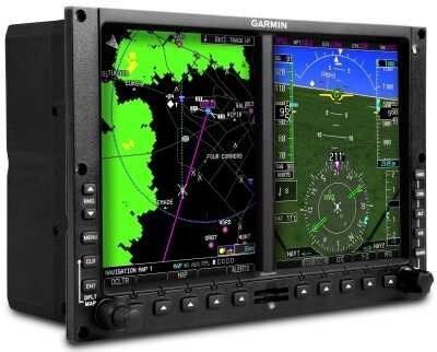
The FAA has granted an STC for the Garmin's G500H, an all-glass avionics system designed specifically for the VFR Part 27 helicopter market. The STC is for the Bell 206-series and Bell 407 helicopters, Garmin announced Thursday.

The GPS maker says the G500H is optimized for the rotorcraft market and it builds upon the best features of the G600 and G500, which are for the fixed-wing aircraft market. The G500H offers capabilities like over 900 SafeTaxi airport diagrams, optional helicopter synthetic vision technology (HSVT), optional XM WX Satellite Weather with NEXRAD, and the option to display video from a forward looking infrared (FLIR) camera or other video sources.

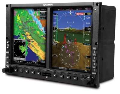
The G500H is available in two versions - one with the PFD on the right, the other version with the PFD on the left. The PFD screen displays attitude, airspeed, vertical speed, altitude and course/heading information, and the MFD shows detailed moving map graphics with the helicopter's current position in relation to terrain, chart data, navaids, and flight plan routings. The G500H communicates and integrates with Garmin's other panel mount products, such as the GNS 430W/530W series.

The G500H is also compatible with Garmin's new GSR 56 Iridium transceiver. This optional worldwide position tracking solution enables aircraft location data to be monitored via web-based displays on authorized base-ops computers.

Customers may interface the G500H with Garmin's TAS and TCAS I traffic systems, the GTS 800, GTS 820 and GTS 850, which are optional equipment. The Garmin traffic systems combine active and passive surveillance data to pinpoint specific traffic threats.

The G500H is available immediately for an expected introductory price of $24,995. The G500H includes the GDU 620 display/control unit, GRS 77H AHRS, GDC 74H digital air data computer, GMU 44 tri-axial magnetometer, and GTP 59 temp probe. Garmin's HSVT is also available immediately as a G500H option for $7,995.

FMI: www.garmin.com/helicopters

Advertisement

More News

ANN's Daily Aero-Term (05.05.25): Circle To Runway (Runway Number)

Circle To Runway (Runway Number) Used by ATC to inform the pilot that he/she must circle to land because the runway in use is other than the runway aligned with the instrument appr>[...]

ANN's Daily Aero-Linx (05.05.25)

Aero Linx: National Aviation Safety Foundation (NASF) The National Aviation Safety Foundation is a support group whose objective is to enhance aviation safety through educational p>[...]

NTSB Prelim: De Havilland DHC-1

At Altitude Of About 250-300 Ft Agl, The Airplane Experienced A Total Loss Of Engine Power On November 6, 2024, at 1600 central standard time, a De Havilland DHC-1, N420TD, was inv>[...]

Classic Aero-TV: The Boeing Dreamliner -- Historic First Flight Coverage

From 2009 (YouTube Edition): Three Hour Flight Was 'Flawless' -- At Least, Until Mother Nature Intervened For anyone who loves the aviation business, this was a VERY good day. Afte>[...]

Airborne-NextGen 05.06.25: AF Uncrewed Fighters, Drones v Planes, Joby Crew Test

Also: AMA Names Tyler Dobbs, More Falcon 9 Ops, Firefly Launch Unsuccessful, Autonomous F-16s The Air Force has begun ground testing a future uncrewed jet design in a milestone tow>[...]

blog comments powered by Disqus


Advertisement

Advertisement

Podcasts

Advertisement

© 2007 - 2025 Web Development & Design by Pauli Systems, LC