Drone Power Line Inspection Begins In Nebraska | Aero-News Network
Aero-News Network
RSS icon RSS feed
podcast icon MP3 podcast
Subscribe Aero-News e-mail Newsletter Subscribe

Airborne Unlimited -- Most Recent Daily Episodes

Episode Date

Airborne-Monday

Airborne-Tuesday

Airborne-Wednesday Airborne-Thursday

Airborne-Friday

Airborne On YouTube

Airborne-Unlimited-06.17.24

Airborne-NextGen-06.18.24

Airborne-Unlimited-06.12.24 Airborne-FltTraining-06.13.24

Airborne-Unlimited-06.14.24

Wed, Feb 12, 2020

Drone Power Line Inspection Begins In Nebraska

Aircraft Will Be Used To Take Photos Of Structures Along A High-Powered Transmission Line

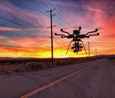
Residents in northeast Nebraska may be seeing some drones flying around, as inspection work begins on a Nebraska Public Power District (NPPD) transmission line that extends from north of Norfolk, through Pierce County and into Antelope County.

Work is scheduled to begin Feb. 10, when drones will be used to take photos of structures along the high-powered transmission line. The photos are being taken so that NPPD can assess any maintenance work that may need to be completed along the line.

NPPD’s contractor, Valmont Utility, a business segment of Valmont Industries, Inc., will be conducting the drone work over a period of approximately five weeks and will be utilizing up to two drones simultaneously.  

“We recently conducted similar work on a transmission line in Fillmore County, and as we begin drone work in Madison, Pierce and Antelope counties, we want people to be aware of what’s going on,” says NPPD T&D Construction and Maintenance Manager Scott Walz. “The drones will be flying along our transmission lines and will only be operating during daytime hours.”

The drones will not be operating until at least 30 minutes after sunrise and will finish operating at least 30 minutes before sunset.

“Valmont partners with our key utility customers to understand the conditions of the assets required for grid reliability,” says Angi Chamberlain, Director of Quality for Valmont Utility. “The use of drones, or UAS, to survey and monitor the conditions of existing utility infrastructure allows a minimally invasive method to quickly ensure assets are in compliance with the original specifications and will maintain structural integrity over their lifetime. This is the most effective way to monitor the reliability of these critical assets,” adds Chamberlain.

(Source: Nebraska Public Power District news release. Image from file)

FMI: www.nppd.com

Advertisement

More News

USCG MH-60 To The Rescue (Again) -- Rescues 4 Boaters

Capsized Vessel Located Near Dauphin Island, Alabama The Coast Guard rescued four boaters after their vessel capsized near Dauphin Island, Alabama, Thursday. Coast Guard District E>[...]

Gray Eagle Order Placed for Army National Guard

Reserve Components Looking to Improve In-House General Atomics Aeronautical Systems announced a fresh order for a dozen Gray Eagle 25M UAVs with accompanying equipment, for fulfill>[...]

Aero-Biz Survival 101 (1120a): Expert Ideas To Help You Through Tough Times

Brand New! Avoid The Need For A Comeback... Get Your Marketing Right, Right Now! Some time ago, the Aero-News Network, responding to numerous requests, established a marketing and >[...]

Airborne 06.03.24: Rotax 915/916 SB, Starship 4 Ready?, B-17 Mementos

Also: Hubble On Pause, FedEx Pilots Picket, Nexus eVTOL, VFS Honors The Rotax folks have published a Service Bulletin after issues were noted that may affect all R915i and R916i se>[...]

Mid-Continent Instruments and Avionics Mourns Former Leader

John W. Winter of AEA and Avionic Fame Passes John W. Winter brought Mid-Continent Instrument Company into the modern era in 1980, purchasing the firm and using it as a base for ex>[...]

blog comments powered by Disqus


Advertisement

Advertisement

Podcasts

Advertisement

© 2007 - 2024 Web Development & Design by Pauli Systems, LC