NTSB Prelim: Lancair NLA-275-FR-C | Aero-News Network
Aero-News Network
RSS icon RSS feed
podcast icon MP3 podcast
Subscribe Aero-News e-mail Newsletter Subscribe

Airborne Unlimited -- Most Recent Daily Episodes

Episode Date

Airborne-Monday

Airborne-Tuesday

Airborne-Wednesday Airborne-Thursday

Airborne-Friday

Airborne On YouTube

Airborne-Unlimited-09.08.25

AirborneNextGen-
09.09.25

Airborne-Unlimited-09.10.25

Airborne-AffordableFlyers-09.11.25

AirborneUnlimited-09.12.25

Fri, Sep 12, 2025

NTSB Prelim: Lancair NLA-275-FR-C

About 2132 And At 11,800 Ft MSL, The Airplane Began A Rapid Right Spiraling Descent

Location: Bradley, AR Accident Number: CEN25FA321
Date & Time: August 18, 2025, 21:33 Local Registration: N345LA
Aircraft: Lancair NLA-275-FR-C Injuries: 1 Fatal
Flight Conducted Under: Part 91: General aviation - Personal

On August 18, 2025, about 2133 central daylight time, a Lancair NLA-275-FR-C airplane, N345LA, was destroyed when it was involved in an accident near Bradley, Arkansas. The pilot was fatally injured. The airplane was operated as a Title 14 Code of Federal Regulations Part 91 personal flight.

A preliminary review of ADS-B data showed the airplane departed Lakeway Airpark, Lakeway, Texas, about 2011. The airplane then proceeded on a predominant northeast course. At 2018, the airplane reached an altitude of about 10,000 ft mean sea level (msl). After about 50 minutes, the airplane began a climb to an altitude of about 12,175 ft msl. After about 18 minutes, the airplane climbed to maximum altitude of about 14,125 ft msl, followed by a descent to about 12,375 ft msl.

The airplane then began a climb from 12,375 ft msl to 12,675 ft msl, followed by a descent. About 2132 and at 11,800 ft msl, the airplane began a rapid right spiraling descent. Near the end of the descent, the data indicated that the airplane made a momentary level off and climb before a descending left turn into terrain.

The main wreckage of the airplane was located in wooded terrain. The initial impact point was a pine tree about 200 ft from the main wreckage. The path from the initial impact point to the main wreckage was on a true heading of 066°. The debris field from the initial impact point to the main wreckage contained fragments of the right wing.

The main wreckage was oriented with the airframe upright and the engine was inverted with a final heading of 180°. The airplane was destroyed by the impact sequence and the postimpact fire.

The wreckage was recovered from the accident site and was transported to a secure location for future examination.

FMI: www.ntsb.gov

Advertisement

More News

ANN's Daily Aero-Term (09.10.25): Runway Entrance Lights (REL)

Runway Entrance Lights (REL) An array of red lights which include the first light at the hold line followed by a series of evenly spaced lights to the runway edge aligned with the >[...]

Airborne 09.04.25: Textron Nixes EPlane, Space Command!, CO MidAir

Also: Daher Climate Policy, Boeing Reveal, Another Laser Whacko, Spirit Proceeds Textron eAviation is putting the development of its Nexus eVTOL aircraft on hold, meaning its first>[...]

Airborne Affordable Flyers 09.11.25: MWAE25, Tests-Flt Design F2, Vashon Ranger

Also: SUN ‘n FUN’s EarlyBird, Rotax Advanced Start, Girls in Aviation Day, Lockwood RV-916! The recently concluded Midwest Aviation Expo, hosted by the Mt. Vernon Outla>[...]

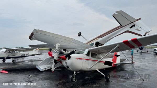
Airborne 09.10.25: 1000 Hr B29 Pilot, Airplane Pile-Up, Haitian Restrictions

Also: Commercial A/C Certification, GMR Adds More Bell 429s, Helo Denial, John “Lucky” Luckadoo Flies West CAF’s Col. Mark Novak has accumulated more than 1,000 f>[...]

Airborne 09.08.25: Swift Fuel Approval, ‘Diamond Lil’ Roars, SnF26 Tkts On Sale!

Also: Carrier Landings Not Required, UAL To Tel Aviv, ATC in College, EMAS Systems Stop 2 Swift Fuels 100R unleaded fuel has earned ASTM production specification approval. This 100>[...]

blog comments powered by Disqus


Advertisement

Advertisement

Podcasts

Advertisement

© 2007 - 2025 Web Development & Design by Pauli Systems, LC